


Live Coverage: Tornado Warnings Issued as Severe Storms Threaten OKC Metro
Severe thunderstorms moved across Oklahoma on Friday, producing multiple warnings and localized damage. Filmogaz.com tracked the event as storms brought hail, damaging winds, flash flooding, and a low tornado threat.
Overview of threats and risk levels
A level 2 slight risk covered much of Oklahoma, including the OKC metro. A separate level 1 marginal corridor affected areas near Woodward, Alva, and parts of far southeastern Oklahoma.
Meteorologist Mikayla Smith said hail, 60-70 mph wind gusts, and flash flooding were possible. The tornado index was low, at 2 out of 10.
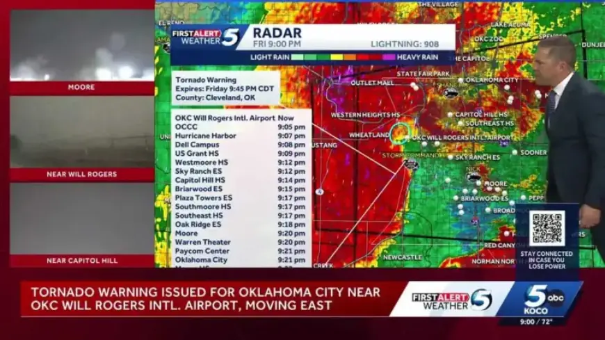
Warnings, watches and alerts
At 3:30 p.m., the National Weather Service issued a severe thunderstorm watch for dozens of counties. The watch remained in effect until 10 p.m.
Throughout the evening, agencies issued numerous tornado warnings, severe thunderstorm warnings, and flash flood warnings across central and western Oklahoma.
Notable warnings
- Early evening tornado warnings affected southeastern Washita and northeastern Kiowa counties. Communities named included Gotebo and Mountain View.
- Severe thunderstorm warnings listed threats of 60 mph gusts and hail up to ping-pong, quarter, nickel, and golf-ball size.
- Flash flood warnings covered parts of Canadian, Grady, and Caddo counties into late night hours.
- By late evening, tornado warnings included portions of Grady, Oklahoma, Cleveland, Canadian, and McClain counties.
Timeline of storm activity
Scattered showers appeared around 3 p.m. Storms expanded into southwestern, central, and northern Oklahoma by 5-6 p.m.
The first major wave moved through between 4 and 8 p.m. It produced hail, damaging winds, and isolated tornadoes. A second wave arrived from 10 p.m. to midnight with heavy rain and flooding risk.
Key evening developments
- 6:45 p.m. — Tornado warning for parts of Washita and Kiowa counties.
- 7:55–8:45 p.m. — Multiple tornado and severe storm warnings across Caddo, Grady, and Canadian counties.
- 8:35–11:45 p.m. — Flash flood warnings for southeastern Canadian and northern Grady counties.
- 9:08 p.m. — A possible tornado was reported near Will Rogers International Airport. Reports mentioned power outages and flight delays.
Impacts and advice
Storms damaged infrastructure in some locations. Airport operations experienced delays after the late-evening report near Will Rogers Airport.
Officials advised residents in warned areas to take shelter immediately. Motorists were urged to avoid flooded roadways and to report hazardous conditions.
Forecast and meteorology team
Meteorologist Mikayla Smith outlined the two-wave scenario and the main hazards for each wave. Chief Meteorologist Damon Lane provided live reporting and situational updates.
Filmogaz.com noted KOCO 5’s First Alert Weather Team has been certified by WeatheRate as providing Oklahoma City’s most accurate forecast for 14 consecutive years.
Live coverage continued as tornado warnings were issued while severe storms threatened the OKC metro. Residents should monitor local alerts and prioritize safety through the night.