


Ice Storm Prompts First Alert Weather Day This Thursday
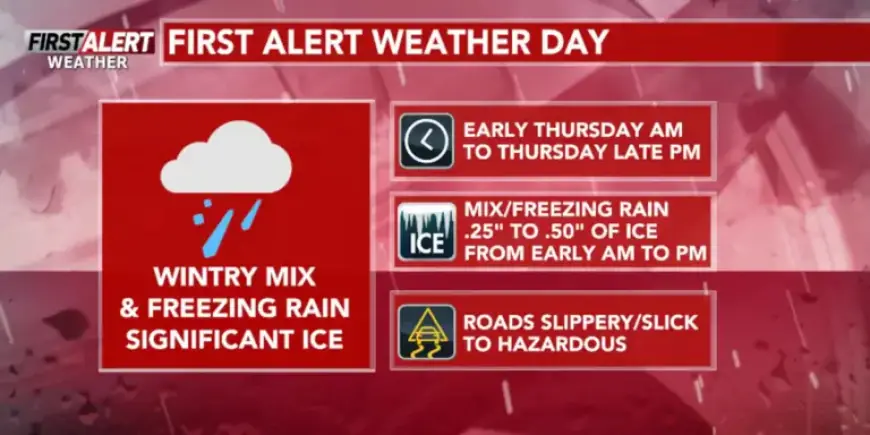
Wausau, Wis. — An ice storm prompts a First Alert Weather Day on Thursday. Expect significant icing and travel impacts across central Wisconsin.
Timing and coverage
Precipitation moves in from the south overnight. Central Wisconsin should see a wintry mix and freezing rain between 2 AM and 4 AM on Thursday.
The Northwoods will see light snow through about 6 AM. That will change over to a wintry mix as the morning progresses.
Precipitation changes through the day
Freezing rain and sleet will affect much of the region during Thursday morning. South of Highway 10, precipitation should transition to rain by midday.
Around Highway 29, the switch to rain is expected in the early to mid-afternoon. Farther north, the wintry mix may persist into mid to late afternoon.
Expected ice amounts
Most locations could pick up 0.25 to 0.50 inch of ice from Thursday morning into the afternoon. That amount raises the risk of power outages and tree damage.
Travel and public safety
Roads will be icy and slick, especially during the Thursday morning commute. Treated major roads may become wet, but secondary roads, bridges, and overpasses could stay icy.
Motorists should allow extra travel time and prepare for hazardous conditions. Power and service disruptions are possible as ice accumulates.
Severe threat Thursday afternoon and evening
There is a localized risk of thunderstorms late Thursday afternoon into the evening. Areas from Stevens Point southeastward face the greatest chance for storms.
- Primary threats: gusty winds, hail, and heavy downpours.
- Stronger storm chances increase farther southeast in Wisconsin.
Short-term outlook: Friday into the weekend
Friday daytime should be a brief lull in wintry precipitation. However, a new low pressure system arrives Friday night into Saturday morning.
Forecasters are monitoring freezing rain potential in the Northwoods Friday night. That event could produce about 0.10 to 0.25 inch of ice and may warrant another First Alert.
Weekend and next week forecast
Central Wisconsin will likely see rain showers Friday night into Saturday morning. Saturday will remain mostly cloudy with highs in the low to mid 40s.
Easter Sunday looks mostly cloudy, with highs in the low to mid 40s. Monday brings a chance of snow showers and highs near the upper 30s.
Tuesday will be chilly with partly cloudy skies and highs in the mid to upper 30s. Wednesday may feature occasional rain showers with highs returning to the low to mid 40s.
Stay tuned to Filmogaz.com for updated forecasts and safety advice as this situation evolves.