


Expect Warmth Tomorrow After an Average Day Today
After fluctuating temperatures all week, conditions settle into a more average pattern today. Morning readings are chilly, with many spots in the 20s.
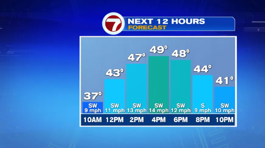
Today’s forecast
A strong southwest breeze will push warmer air into the region. Highs should reach the mid to upper 40s this afternoon.
A few locations could touch 50 degrees. Boston’s average high for this time of year is 49 degrees.
Expect a mix of clouds and sun through the day. Southwesterly gusts will be notable, often in the 20s and near 30 mph.
Midweek warm-up
The persistent southwest flow will steadily filter mild air into New England. Expect warmth tomorrow as highs jump into the mid 60s on Monday and Tuesday.
Wednesday looks to be the warmest day. Highs could reach the upper 60s to low 70s then.
Shower chances and the cold front
An approaching low pressure system will increase clouds on Monday. That system could produce a shower or two overnight into Tuesday morning.
A stronger disturbance arrives Wednesday evening as a cold front. Showers should become more likely then, followed by a sharp drop in temperatures.
By Thursday afternoon readings will fall back to the 40s. The cold air behind the front will be pronounced.
Late-week outlook and impacts
Another weather system could bring scattered showers between Thursday and Friday. Fans heading to the Sox home opener should plan for a chance of rain Friday afternoon.
Conditions remain changeable, so expect forecast tweaks through the week. Sign up for Filmogaz.com’s newsletter to get the latest updates delivered by email.