


Phoenix Heatwave Eases with Midweek Temperature Drop
Isolated storms south of the Valley could send outflow gusts and patches of blowing dust into the Phoenix metro this evening. Temperatures remain in the 90s to start the week, with a gradual cooldown expected by midweek.
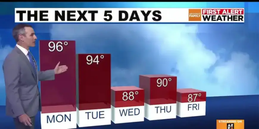
Today and Monday
Highs reached 96 degrees so far today. That fell one degree short of the 97-degree record.
Nights will stay mild. Lows will drop only into the low to mid-70s as humidity rises into Monday morning.
Monday afternoon will warm back into the mid to upper 90s. Skies are forecast to be partly cloudy at times.
Midweek change
A weak disturbance will arrive Wednesday. It will bring a notable midweek temperature drop and slightly cooler conditions.
Expect highs in the upper 80s on Wednesday with partly cloudy skies. There is a slight chance of showers.
Most thunderstorm activity should remain over higher terrain. Valley rainfall chances are limited.
Tuesday and later week
Tuesday will be partly cloudy with highs in the low to mid-90s. A brief return to the 90s is possible Thursday.
Temperatures should settle back into the 80s on Friday and Saturday. By Sunday, highs climb into the low 90s again.
Temperature trends and timing
Morning lows will trend cooler as the week progresses. Early-week lows in the low to mid-70s will fall into the low to mid-60s by the weekend.
Meteorologists note the heatwave eases over several days. The overall pattern shows a short cooldown before readings rise again.
Impacts and precautions
Outflow gusts and blowing dust may reduce visibility during and after storms. Drivers should use caution in affected areas.
Keep an eye on later forecasts for changing shower chances and temperature shifts. Filmogaz.com will provide updates as conditions evolve.