


Skiers at Snoqualmie Pass face whiteouts as Blizzard Warning hits Cascades
Shawn Chitnis is at Snoqualmie Pass, where roads are slick and skiers are shredding fresh snow. A blizzard warning is going into effect for the Washington Cascades from Wednesday evening into Thursday morning, bringing heavy mountain snow, strong winds and a heightened avalanche threat that changes how people travel and recreate in the high country.
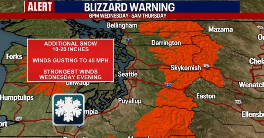
Blizzard Warning for Washington Cascades and the timing of the threat
A Blizzard Warning will remain in effect for the Washington Cascades from 9: 00 pm ET Wednesday through 8: 00 am ET Thursday. Forecasters note the best chance for blizzard-like or whiteout conditions will be after 1: 00 am ET or 2: 00 am ET Thursday, and gusty winds will create near-whiteout conditions for the mountains Wednesday night.
Higher elevations are forecast to receive between 10 to 20 inches of new snow while wind gusts could reach up to 45 mph. For people already on the road or planning trips into the passes, those numbers translate into limited visibility and treacherous driving on the mountain corridors.
Northwest Avalanche Center warns about backcountry danger
Meteorologist Abby Acone emphasized that avalanche danger is focused on backcountry areas rather than managed ski areas or main roads. The Northwest Avalanche Center rates areas on the west side of the Washington Cascades at four out of five, a level the center describes as dangerous and potentially life-threatening for backcountry travel.
Eastern slopes of the Cascades are assessed one level lower, at “considerable” avalanche danger. Acone noted that avalanche mitigation teams operate at ski resorts and that the avalanche threat they discuss is aimed at skiers and snowboarders who venture into ungroomed backcountry terrain.
Brian MacMillan’s forecast for mountain snow and lowland impacts
Chief Meteorologist Brian MacMillan and other forecasters say a strong cold front will bring rain and gusty winds to the lowlands Wednesday while the higher terrain sees heavy snow. Gusty winds in the mountains are expected to make conditions worse for travel and can contribute to rapidly changing snowpack stability.
Forecasters also point out that while snow will continue through the weekend, conditions are expected to shift. Saturday and Sunday are forecast to be better for skiers and snowboarders, but a sudden temperature increase on Monday and Tuesday could change precipitation from snow to rain, altering both snowpack and road conditions.
Road crews and avalanche teams have different missions: WSDOT focuses on plowing and keeping corridors open, while resort teams use mitigation to protect managed areas. Backcountry users do not have those layers of protection, and forecasters warn that a blizzard warning and high avalanche ratings change the risk calculus for anyone outside groomed areas.
For now, Snoqualmie Pass remains a focal point: roads are slick and fresh snow is attracting skiers, even as warnings are posted for the higher terrain. The blizzard warning begins at 9: 00 pm ET Wednesday and runs through 8: 00 am ET Thursday, and the next confirmed milestone is the expected window of the worst visibility after 1: 00 am ET or 2: 00 am ET Thursday.
Shawn Chitnis’s report from Snoqualmie Pass closes the loop: the pass shows both immediate impacts on travel and the draw of new snow for recreation, while forecasters and the Northwest Avalanche Center urge caution for anyone considering backcountry travel during the period of heavy snow and strong winds.


