


Tornado Emergency language absent as Kerr County braces for severe weather
Kerr County is preparing for a round of severe weather from Tuesday, March 10, through Wednesday, March 11, as the National Weather Service warned of thunderstorms, flooding, damaging high winds, and possible tornadoes. While the alert details stop short of using tornado emergency terminology, the combination of hazards—especially the potential for large hail and tornadoes—raises the stakes for overnight planning.
Kerr County and National Weather Service
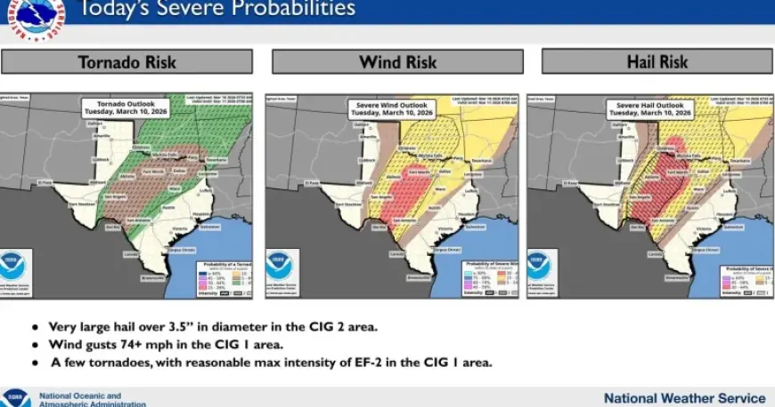
The National Weather Service forecast described a multi-hazard period that includes thunderstorms and rain, along with flooding and damaging high winds. A specific hail risk was also highlighted: a possibility of up to 3. 5-inch sized hail. The figures point to an event that is not limited to lightning and heavy rain; it is framed as a severe-weather window with multiple threats that can develop quickly within the same storm line.
Forecast details also included baseline conditions: a low of 56F and south winds shifting to ENE at 10 to 20 mph, with a 100% chance of rain. Those elements matter because they underscore confidence in precipitation and a period of active weather, rather than a marginal chance that might only affect parts of the county.
March 10–11 threat window
The timing laid out for Kerr County—Tuesday, March 10, through Wednesday, March 11—sets expectations for a prolonged risk rather than a brief afternoon burst. That extended window can complicate decisions for residents because preparedness may need to hold through changing conditions overnight and into the next day, especially with threats that include flooding and damaging winds alongside the possibility of tornadoes.
One narrowing detail stands out: the National Weather Service said the concern should be reduced between midnight and 5 a. m. Wednesday. The pattern suggests the most intense period is expected earlier, before that overnight lull, with a tapering of concern during those hours. Still, “reduced” is not the same as “removed, ” and the forecast keeps tornadoes on the list of possible impacts in the area.
Tornado Emergency messaging and risk clarity
The forecast language emphasizes preparedness for tornadoes without invoking a tornado emergency label. That distinction matters for public understanding: the alert is explicit about tornado potential, hail up to 3. 5 inches, flooding, and damaging winds, yet it does not frame the situation in the most extreme terminology. The figures point to a scenario where people may need to make practical preparations based on the hazards listed, even if the wording remains measured.
For now, the clearest open question is how the severe threats—particularly tornado potential and the risk of very large hail—will evolve across Kerr County within the Tuesday-to-Wednesday timeframe, and whether later updates keep the same level of concern before conditions are expected to ease between midnight and 5 a. m. Wednesday.


