


Chicago Weather Today: Level 4 Tornado Threat Active Right Now Across Illinois and Indiana — Nighttime Tornado Risk Highest
This is not a routine spring storm. A rare Level 4 of 5 severe weather outbreak is unfolding across Illinois and Indiana tonight, with rotating supercells already on the ground, tornado watches in effect, and the Storm Prediction Center warning of EF-3 or stronger tornadoes possible after dark. Chicago sits at 40°F and cloudy — but the real danger is south and east of the city, moving fast.
Chicago Weather Today: Current Conditions and Wednesday Forecast
Chicago is currently sitting at 40°F under full cloud cover. Tuesday's high reached 49°F with a 20% chance of rain. Wednesday drops sharply — high of 39°F with a 45% chance of snow as the cold side of this system pushes through. Thursday through Saturday stays in the low-to-mid 40s with lingering snow chances each day.
The pleasant temperatures Chicago saw Tuesday are borrowed time. The front that is generating tonight's tornado outbreak will drag cold, unstable air into the metro Wednesday morning.
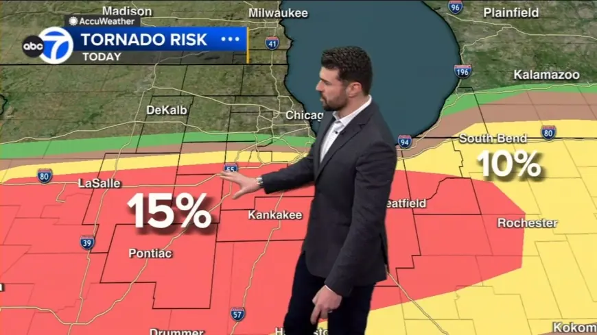
Storm Prediction Center Issues Rare Level 4 Severe Weather Threat — Tornado Watches Active Now
The Storm Prediction Center issued a rare Level 4 of 5 threat area for a corridor stretching from northern Illinois into northwest Indiana. All severe hazards are on the table tonight — including the potential for intense tornadoes rated EF-3 or higher, damaging wind gusts up to 70 mph, and large hail.
A Tornado Watch is in effect through 11:00 p.m. CT for portions of Illinois, Indiana, and Iowa. Forecasters are particularly concerned about the potential for intense, long-tracked, fast-moving tornadoes.
GOES-19 satellite imagery captured a supercell thunderstorm that produced a confirmed tornado in Illinois towering into the upper atmosphere. The "overshooting tops" visible from space are a direct signature of intense updrafts — the engine driving tornado-producing storms on the ground.
Indianapolis Weather Today: 69°F, 85% Rain Chance Wednesday, Ground Zero for Outbreak
Indianapolis is the warmest and most exposed metro in tonight's threat corridor. Current temperature: 69°F. Tuesday's high hit 73°F — nearly 20 degrees above normal for mid-March. Wednesday brings an 85% chance of rain as the system pushes through, with temperatures crashing to a high of just 46°F by Thursday.
SPC Warning Coordination Meteorologist Evan Bentley confirmed the setup: "Large hail, severe wind gusts and tornadoes are all possible on Tuesday. The greatest tornado threat is expected across parts of the Midwest with the greatest severe wind threat across parts of Texas. Large hail is also likely in both regions."
Nighttime Tornado Risk Is the Critical Warning Tonight
As daylight fades, the primary concern shifts to the nighttime threat. A strengthening low-level jet — a fast-moving stream of air just above the surface — will continue pumping warm, moist air into the region, allowing storms to maintain their intensity long after sunset. Nighttime tornadoes are statistically twice as deadly as those that occur during the day because they are difficult to see and often strike while people are asleep.
The Weather Prediction Center confirmed: widespread thunderstorms with a severe weather and flash flood risk are expected across the Midwest and central and southern Plains through tonight, shifting east Wednesday.
Context: Eight Killed Just Days Ago in the Previous Outbreak
This is the second major outbreak in a week. Between last Thursday and Saturday, at least a dozen tornadoes tore across parts of Texas, the Plains, and the Midwest. The deadly tornado in Union City, Michigan, reached EF-3 strength with winds exceeding 136 miles per hour. The storms killed eight people and left neighborhoods damaged and families displaced.
Bentley said: "Severe weather potential will remain for the rest of this week before a quieter pattern arrives this weekend. Early in the season, severe weather is often sporadic, but impactful when it does occur."
Residents across northern Illinois, northwest Indiana, and the Indianapolis metro should have multiple ways to receive warnings active tonight — phone alerts, weather radio, and local broadcasts. Do not wait for sirens.


