


Winter Storm Warning: Cascades brace for blizzard conditions as North Sound wakes to surprise snow
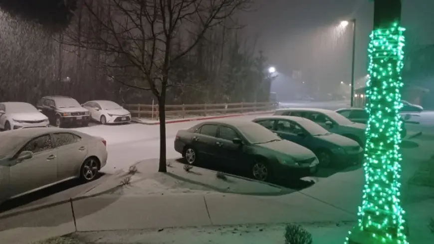
Parts of Washington’s North Sound woke to snow early Tuesday morning, a reminder that a winter storm warning can take shape quickly when lowland flakes coincide with rapidly worsening mountain conditions. Arlington, Everett, Granite Falls, Lake Stevens, Oso, and Marysville were among the communities blanketed by the early burst. The sharper risk, however, is aimed at the higher elevations: a blizzard warning is set to begin Wednesday night across broad sections of the Cascades, with wind and heavy snow threatening travel through key passes.
Mountain alerts tighten: blizzard warning window and high-impact zones
A blizzard warning is scheduled to run from 6: 00 pm ET Wednesday to 5: 00 am ET Thursday for all of the Cascades of Snohomish, northern and southern King, Lewis, Pierce, Skagit, and Whatcom counties. The warning area also includes Greenwater, Crystal Mountain, White Pass, Ashford, Mount Rainier, Snoqualmie Pass, Paradise, SR 18 at Tiger Mountain Summit, and Longmire.
Winds gusting as high as 45 mph are expected in the mountains, and forecasters say snow totals could reach 4–5 feet or more at ski resorts as mountain snow piles up over the Cascade and Olympic mountains. The combination of blowing snow and gusty wind can sharply reduce visibility and raise the odds of difficult-to-impossible travel on mountain routes, including the possibility of temporary road closures.
In addition to the blizzard warning, a winter weather advisory runs until 6: 00 pm ET Wednesday, and a winter storm watch extends from late Wednesday night through late Friday night. Taken together, the alert progression signals a long-duration stretch of hazardous mountain travel, where conditions can deteriorate in stages rather than all at once. For travelers and freight alike, that sequencing matters: it can encourage risky “window chasing” ahead of the worst impacts, even while wind and accumulating snow are already creating trouble.
Lowlands: surprise snow, school delays, then rain and gusty winds
The initial lowland snow carried immediate, practical consequences. Five public school districts announced two-hour delays, and another shifted to snow routes. Yet the weather pattern described for Tuesday points toward a transition from early wintry surprises to a wetter, windier setup through the day.
Showers were expected to pick up closer to lunchtime from Long Beach through Westport and Port Angeles into the San Juan Islands. The rain was then expected to move through SeaTac and Renton during the mid-afternoon, leaving behind scattered showers for the evening commute. While this is not the same as a winter storm warning for the lowlands, it underscores how quickly the region’s hazards can pivot: slick surfaces early, reduced visibility later, and stronger winds as the system evolves.
Wind gusts above 30 mph from the south or west were possible Tuesday, with the strongest period expected Wednesday evening and overnight. A compact low-pressure area was forecast to form and sweep in, bringing south-to-west winds above 50 mph and a risk for a few power outages. That wind threat adds a second dimension to the mountain snow risk: gusts can limit visibility, knock down tree branches, and complicate response efforts when road access is already constrained.
Atmospheric river effect: heavy mountain snow and meaningful rainfall totals
The passing storm is embedded within an atmospheric river, though it is described as not as strong or long-lasting as the one experienced in December. Even so, it has the potential to deliver 1–2 inches of rainfall around Seattle and Redmond, with more than double that amount from Olympia through Chehalis through the weekend.
This is where the forecast becomes especially consequential for planning across the region. Heavy mountain snow can coincide with sustained lowland rainfall, creating simultaneous disruptions: mountain pass travel becomes unreliable while urban and suburban corridors deal with periods of wind-driven rain. At the same time, the expected surge of mountain snow “by this evening” suggests that conditions may intensify before the blizzard warning window formally opens, making it important for drivers to treat the entire midweek period as elevated risk.
Across the broader Cascades in Washington and northern Oregon, winter weather advisories were in effect through Wednesday afternoon, and the National Weather Service warned that up to 10 inches of snow could fall above 3, 000 feet by 5: 00 pm ET Wednesday. Wind gusts up to 35 mph could further complicate travel through Cascade passes. In the south Washington Cascades, a winter storm watch was set to take effect after the advisory ends, from Tuesday afternoon through Wednesday afternoon, with a second system that could bring another 18 inches of snow alongside gusts up to 35 mph.
These overlapping advisories, watches, and the blizzard warning illustrate a key point: while a winter storm warning often reads like a single event, the operational reality is a chain of hazards—snow level shifts, wind surges, and multiple waves—that can keep roads and communities off balance for days.
What to watch next: passes, power outages, and late-week shift
Forecast details highlight several near-term indicators that will shape how disruptive the week becomes:
- Mountain pass conditions, where snow and wind can swing travel from difficult to impossible, with temporary closures possible.
- Wednesday evening wind peak, when the strongest gusts are expected and power outages become a greater concern.
- Rainfall persistence in the Seattle-Redmond area and heavier totals expected farther south from Olympia through Chehalis into the weekend.
Toward the end of the work week, the region is expected to see higher temperatures and widespread, steady rain. For residents and travelers, that shift can feel like relief—but it can also prolong disruption if it arrives while mountain corridors remain difficult and crews are still clearing snow and addressing wind impacts.
For now, the clearest message is timing and terrain: lowland conditions may fluctuate, but the mountains face a sustained high-impact period. As the alerts evolve from advisory to watch to blizzard warning, the question for many travelers is whether their plans can remain flexible enough to avoid becoming the next casualty of a rapidly escalating winter storm warning environment.


