


Houston Weather: Strong, Severe Storms Possible This Weekend; Storm Alert in Effect
Houston Weather is alerting residents to a multi-day period of unsettled conditions driven by a stalled front that will bring rounds of heavy rain and the potential for strong to severe storms. The weekend threat includes localized flooding and damaging winds, with another possible round of strong storms when a stronger cold front moves through midweek.
Houston Weather: Weekend threat, Rodeo impacts and flood risk
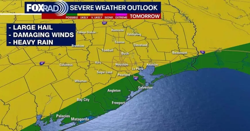
Strong to severe storms are possible Saturday afternoon through early Sunday as a stalled front interacts with warm, humid air. Forecast guidance highlights 1–3 inches of rain broadly, with a few spots that could reach 4 inches or more. That rainfall pattern raises the prospect of street ponding and low-level flooding in some neighborhoods.
Event disruptions are likely: attendees traveling to the Houston Livestock Show and Rodeo and visitors near NRG should prepare for messy ground conditions and potential travel delays beginning as early as Saturday afternoon and continuing through Sunday afternoon. There is an elevated risk—rated 2 out of 5—for severe storms on Saturday, focused on damaging winds and the possibility of some large hail.
People planning outdoor activities on Saturday are advised to have a plan to get indoors quickly if storms approach. The severe storm threat decreases on Sunday, but rounds of heavy rain will continue and keep flood potential elevated in many areas.
Timing outlook and midweek change
The unsettled pattern extends beyond the weekend. Expect lingering unsettled weather through Monday, with only a few additional showers possible on Tuesday. A stronger cold front is forecast to arrive Wednesday, bringing the potential for one final round of strong storms as it pushes through.
When the front clears, it will usher in a cooler, drier air mass for the latter half of the week. Temperatures are expected to drop, with overnight lows moving back into the 50s and daytime highs falling into the 70s in the days after the front passes.
Practical guidance and short-term expectations
- Rain and flooding: Plan for rounds of heavy rain Saturday into early Sunday; localized totals could exceed the general 1–3 inch expectation in a few areas, increasing street flooding risk.
- Severe weather: Elevated severe risk Saturday with damaging winds and isolated large hail; severe threat much lower Sunday.
- Event planning: Travel to and from major event sites may experience delays starting Saturday afternoon; have contingency plans for shelter and alternate routes.
- Midweek shift: A stronger cold front Wednesday could produce another line of strong storms before drier, cooler conditions arrive for the second half of the week.
- Clocks change: Daylight Saving time begins early Sunday morning; plan accordingly when scheduling travel or events.
Forecast details and exact timing may evolve as the systems progress. Recent updates indicate the general weekend-to-midweek timeline and the primary hazards—heavy rain, flooding potential, damaging winds, and a possible midweek round of strong storms—so residents should stay weather-aware and be prepared to adjust plans as conditions change.