


Weather Houston: Strong Storms and Flood Threats Expected at Rodeo; Storm Alert in Effect
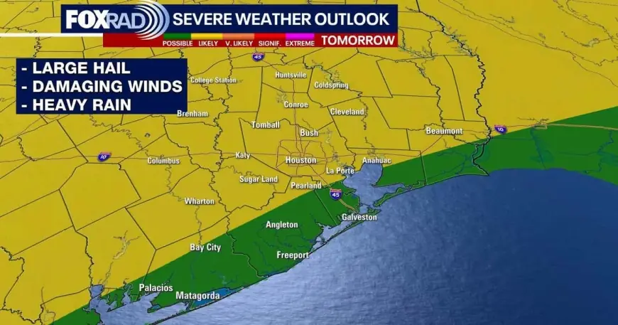
A FOX 26 STORM ALERT is in effect as a stalled frontal boundary moves into the area, creating a heightened chance for strong to severe storms across the region. This window of active weather, stretching from Saturday afternoon into early Sunday, raises both severe-wind and localized flooding concerns at major outdoor venues.
Weather Houston: Houston Livestock Show and Rodeo and NRG travel
Organizers and attendees of the Houston Livestock Show and Rodeo should plan for disrupted travel and muddy conditions at NRG as rounds of heavy rain arrive. Forecasts point to 1 to 3 inches of rain across much of the metro area, with a few pockets potentially receiving 4 inches or more; those totals can produce street ponding and localized travel delays. The risk for damaging winds and some large hail is elevated, with the area placed at a 2 out of 5 risk for severe storms for Saturday. Eventgoers are advised to have a rapid plan for getting indoors if thunderstorms develop during outdoor activities.
Stalled front, rainfall totals and flooding south of I-10
The severe and flood threat is driven by a stalled front interacting with warm, humid Gulf air. That setup is expected to trigger multiple thunderstorm rounds through Saturday into early Sunday, with the front lingering and producing morning rain primarily south of I-10 on Sunday. While the severe-storm threat diminishes Sunday, the flood threat remains elevated because of repeated downpours. One immediate effect will be low-level street flooding in susceptible neighborhoods and slower or delayed commutes where ponding occurs.
Wednesday cold front and temperature shift
After a period of unsettled conditions that extends through Monday and carries small chances for additional showers into Tuesday, a stronger cold front is forecast to sweep through on Wednesday. That front is expected to bring a final round of possible strong to severe storms as it moves across the region, then usher in noticeably cooler, drier air for the latter half of the week. Overnight lows are expected to fall back into the 50s following the front, offering a marked break from the current humid pattern.
The timing matters because the two frontal interactions bookend the week: one stalled boundary produces repeated rain and localized flood risk this weekend, and the subsequent Wednesday front both threatens one more round of strong storms and provides the mechanism to clear humidity and lower temperatures. In practical terms, residents should prepare for disrupted outdoor plans on Saturday and monitor forecasts for the Wednesday system.
Practical steps include monitoring conditions for sudden wind gusts and hail during storms, avoiding flooded roadways, and allowing extra travel time to and from NRG and other event sites when heavy rain is occurring. Remember that clocks move forward early Sunday morning, which may affect timing for events and commutes during the period of lingering showers. Overall, weather houston will be dominated this week by rounds of rain and intermittent severe threat, capped by a colder, drier push midweek that should ease the flood and severe-risk timeline.