


Atlanta Weather: Record heat to 'ring the bell' before weekend severe storm threat
Atlanta weather will push daytime highs into the low 80s this weekend, then shift to a Level 1 severe thunderstorm threat late Saturday as a cold front moves into North Georgia. The warm spell will challenge seasonal highs, and the approaching system raises the risk of damaging winds and hail for parts of the region.
Warmup locks in low‑80s highs, with Metro Atlanta forecast at 82
An expansive subtropical ridge has trapped a warm, humid air mass over the Southeast, driving daytime highs well above the typical March average of 63 degrees. Metro Atlanta is forecast to hit 82 degrees on both Friday and Saturday, and the broader region will see highs in the low to mid‑80s through the weekend.
Morning lows will also be above normal, dropping into the lower 60s in many areas. Dense morning fog may reduce visibility early Saturday, with figures in the forecast showing visibility could fall to as little as a quarter to half a mile during the commute.
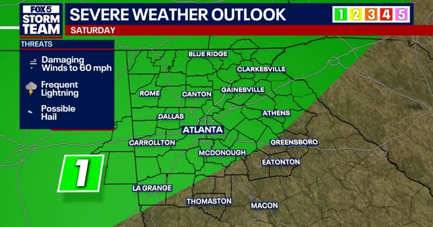
Severe risk set for Saturday night as front moves in
The transition from stagnant warmth to active weather comes with a Level 1 severe weather designation for the northern half of the state on Saturday night. Storms in that window will be capable of producing damaging wind gusts up to 60 mph, frequent lightning, and possible hail.
Model guidance in the briefing highlights wind shear values between 20 and 40 knots — enough to support organized storm clusters — while the cold front is expected to sweep across the eastern U. S. and move into North Georgia. Rain chances climb to roughly 40 percent on Saturday and rise to a more widespread 60 percent on Sunday as the front progresses.
Forecasts differ on how intense the severe threat will be
Chief Meteorologist David Chandley noted the departure from normal conditions and said the pattern could break records: "Is the time to ring the bell? I think we will. In here tomorrow afternoon, with a high of 81. It will get close on Saturday. Tying the record high. " He added that the primary severe timing is after sunset Saturday, which may reduce instability by the time storms arrive.
Another regional forecast characterizes the severe threat as very low while still monitoring for scattered showers and storms mainly Saturday night and Sunday afternoon. That assessment emphasizes widely scattered development and a lower expectation for organized severe outbreaks, even as rain chances and shower coverage increase.
Outdoor plans could be affected by lightning and gusty winds on Saturday afternoon and into the night, and officials note that the high moisture content in the atmosphere could produce efficient rain production and isolated nuisance flooding in some spots.
Temperatures are expected to rebound quickly after the front moves through, with warmth returning early next week; forecasts show the heat pushing back into the low‑ to mid‑80s by Monday and Tuesday.
Daylight Saving Time begins this weekend, with clocks moving forward one hour early Sunday morning. The next notable synoptic event on the schedule is a cold front expected to arrive by Thursday next week, which will bring higher rain and storm chances along with cooler temperatures.