


Tornado Watch issued as tornadic thunderstorms barrel across Central Plains
A Tornado Watch has been issued for central Oklahoma and counties east of Interstate 35, remaining in force until 10 p. m. Friday night. The watch comes as a line of severe and potentially tornadic thunderstorms moved across the Central Plains, creating a heightened threat of damaging winds, large hail and tornadoes into Friday evening.
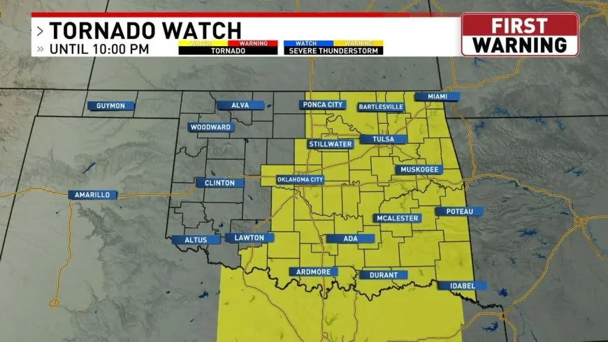
Tornado Watch covers central Oklahoma counties east of I-35
The watch explicitly names six Oklahoma counties: Oklahoma, Cleveland, Logan, Canadian, Payne and Pottawatomie. It is centered on central Oklahoma and extends eastward toward Arkansas, creating an Enhanced severe weather risk in eastern portions of the state and a Marginal to Slight threat across central and western Oklahoma.
Officials have outlined concrete impacts expected with the storms: wind gusts could reach up to 70 mph, hail may be as large as baseballs, and meteorologists have placed a medium risk for tornadoes from midafternoon into the overnight period. The highest concentration of severe activity is forecast to develop after 2PM and continue through the overnight hours, with the Tornado Watch scheduled to expire at 10 p. m. Friday night.
National Weather Service and CIRA tracked storms from Texas to Kansas
Tornadic thunderstorms developed across the central United States on Thursday night, March 5, bringing heavy rain across Texas, Oklahoma and Kansas. The National Weather Service warned of numerous showers and thunderstorms and highlighted the potential for storms with large hail and tornadoes across Oklahoma and Kansas as the system pushed over the region.
Satellite and observational footage compiled by the Cooperative Institute for Research in the Atmosphere (CIRA) captured the severe and tornadic thunderstorms on Thursday night. Forecasters have said the severe weather risk would persist into Friday evening for the southern and central Plains, keeping communities on alert for additional rounds of strong storms.
Dry line, Gulf moisture and wind shear set stage for severe impacts
Forecasters point to a familiar mechanism driving the outbreak: strong instability east of the dry line combined with influxes of Gulf moisture and steady wind shear. Those ingredients are producing bands of strong to severe storms that have the capacity to generate the listed hazards — damaging straight-line winds, very large hail and tornadoes.
The cause-and-effect is clear: the presence of the dry line and available atmospheric energy is enabling storms to intensify, and that intensification translates directly into the risk metrics now attached to the watch. What makes this notable is the overlap of an Enhanced severe risk in eastern Oklahoma with expected overnight timing, which raises the danger because nocturnal storms can be harder to detect and respond to.
Authorities advise that residents in the named counties review severe weather plans, secure loose outdoor items, and be prepared to move to a safe shelter if warnings are issued. The continued presence of large hail and 70 mph gusts elevates the potential for property damage and hazards to travel as storms progress through the evening hours.
With the Tornado Watch active and the system shown to have produced tornadic cells the previous night, meteorologists have emphasized staying tuned for updates and watching for warnings that would indicate a specific, imminent threat to populated areas.