


Tornado Threat Joins Severe Outbreak Forecast From Texas to Iowa
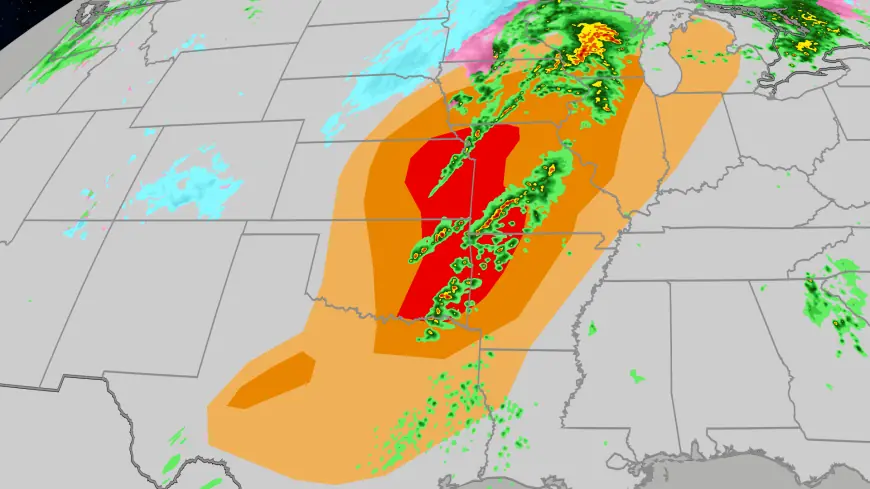
Forecasters are warning that a line of severe storms could produce tornadoes, damaging wind and large hail Thursday as a broad outbreak is expected to span the Plains from Texas to Iowa. The combination of abundant low-level moisture and daytime heating raises the odds of strong to severe cells, with the greatest threat shifting into the late afternoon.
Tornado Threat Across the Plains
Early-morning fog has left the low levels of the atmosphere laden with moisture, and forecasters say that if the necessary lift develops this afternoon, numerous storms will form. Many of those storms are expected to produce severe weather, with damaging wind and hail specifically cited alongside a tornado threat during the late afternoon period. The First Alert Weather Team has emphasized that timing and cloud cover will be decisive: clearing and warming would increase instability and therefore the severity of storms, while persistent cloudiness and cooler temperatures would sharply lower the severe-risk profile.
The cause-and-effect chain is straightforward: plentiful moisture (evidenced by the fog) plus sufficient atmospheric lift and daytime heating will increase convective development, which in turn raises the likelihood of organized severe storms capable of producing tornadoes. What makes this notable is the geographic breadth of the forecast—stretching from Texas up through Iowa—so multiple states could face overlapping hazards within a single afternoon and evening.
North Texas Flash Flood Threat
In North Texas, the threat picture includes heavy rainfall that could lead to flash flooding in addition to severe-wind and hail concerns. Forecast messaging highlights the potential for strong to severe storms with locally heavy rains, and officials urged residents to be prepared for rapid runoff in low-lying and urban areas. The recommendation from the First Alert Weather Team is for residents to use the First Alert Weather phone app to ensure they receive any warnings issued during the event.
Emergency planners note that heavy rain rates over a short period can overwhelm drainage systems and create dangerous conditions on roadways. The forecast therefore couples a tornado and severe-wind threat with a distinct flash-flood risk in parts of North Texas, making situational awareness critical for communities in the expected path.
Public Response and Timing
Officials are urging people in the Plains region to monitor weather updates through the day. The window of highest concern is identified as the late afternoon into the evening, when daytime heating and potential clearing could maximize instability. Conversely, if cloud cover persists and temperatures remain suppressed, the overall severe threat would diminish and, in an extreme scenario, storms could be largely suppressed.
Authorities have also recommended that those who can receive push alerts enable them now and that photographers and storm observers submit any severe-weather images and video to local meteorological teams when it is safe to do so. Continuous coverage will be available for those seeking status updates during the event.
With multiple hazards expected—tornadoes, damaging wind, hail and flash floods—residents across the Plains should have a plan to move to a safe location quickly if warnings are issued. The combination of early-morning moisture and afternoon dynamics creates a conditional environment where small shifts in cloud cover or timing could substantially change outcomes, underscoring the need for real-time information and readiness.