


Omaha Weather: First Alert 6 Weather Day Brings Overnight Storms and Stronger Friday Evening Threat
Omaha Weather will be impacted by two distinct rounds of storms, the first arriving overnight and the second expected Friday afternoon into the evening. The designation of a First Alert 6 Weather Day highlights the potential for severe conditions that could affect travel, power and outdoor plans across the metro.
Omaha Weather: Overnight Rain and Thunder
A first round of showers and thunderstorms is forecast to develop shortly before midnight to the west of the metro and move east, reaching the Omaha area shortly after midnight and lasting into the Friday morning commute. That band of storms will be scattered, so coverage will be uneven; however, a few cells could become severe, producing heavy downpours, frequent lightning, gusty winds and hail. Drivers should expect reduced visibility and localized ponding on roadways during the overnight hours.
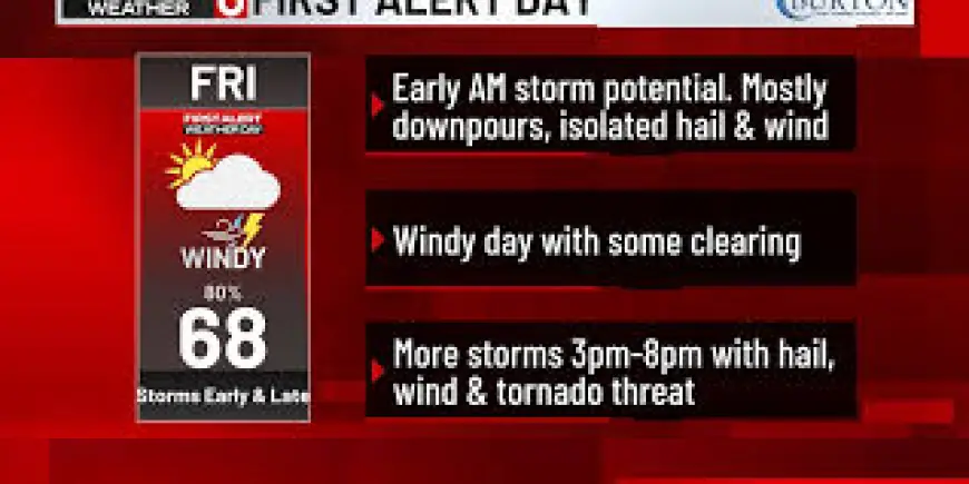
First Alert 6 Weather Day: Evening Severe Threat
After a partial daytime recovery that may warm and recharge the atmosphere, a second, stronger round of storms is expected to form late Friday afternoon and move into the region during the most likely window of roughly 3 p. m. to 8 p. m. That evening round carries the greater severe potential, with large hail and damaging wind gusts singled out as primary threats and the possibility of a few isolated tornadoes, particularly in southeast counties and farther south. Wind direction shifts associated with an advancing cold front will make conditions breezier, with sustained south winds veering northwest and gusts possibly reaching 30 to 45 mph in stronger pockets.
What makes this notable is the timing: the overnight activity threatens the morning commute, while the later round arrives during a period of heavier evening travel and outdoor activity, increasing the chance that severe weather will intersect with people on the move.
Dense Fog Advisory and Wind Forecast
A Dense Fog Advisory remains in effect across much of central and eastern Nebraska and parts of northern Kansas until 11 a. m., where visibility could drop to one-quarter of a mile or less. The fog is expected to dissipate by midmorning, allowing skies to clear enough for temperatures to climb into the 60s in many locations by the afternoon.
Winds are expected to be a significant factor: southeast breezes of 10 to 20 mph with gusts to about 30 mph are possible ahead of the first round, increasing later as the cold front moves through. Forecasts show gusts up to 40–45 mph in some areas during Friday’s strongest storms, and lingering gusty south-southwest winds on Sunday could reach up to 35 mph even as temperatures warm into the 70s. The front will also bring sharply cooler air behind it, shifting conditions and ending the active period into a quieter weekend.
The First Alert 6 Weather Day designation reflects the combination of overnight impacts and a heightened evening threat. Residents are advised to monitor conditions, allow extra time for travel during the overnight and evening periods, and be prepared to seek shelter quickly if severe thunderstorm or tornado warnings are issued.
After the system moves out, forecasts indicate a largely dry and pleasant weekend, with a cooler Saturday followed by a warmer Sunday and only low chances for spotty showers next week.