


Flightradar24 Becomes a Front-Line Tool as Middle East Airspace Chaos Drives Record Traffic
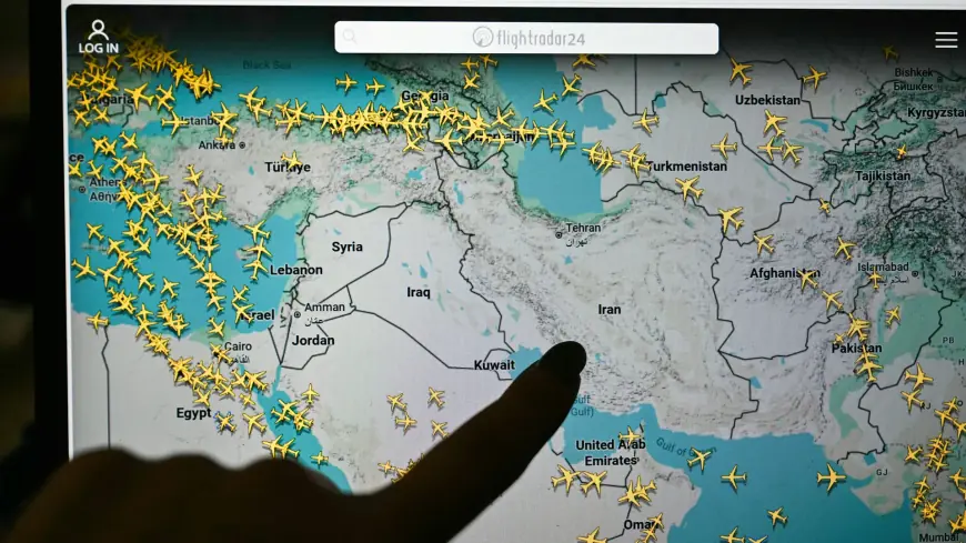
Flightradar24 is having one of those moments when a consumer app suddenly becomes critical infrastructure for public understanding. As flights were canceled, rerouted, and diverted across the Middle East in the last 48 hours, millions of travelers and aviation watchers piled onto live maps to answer a basic question airlines often can’t resolve quickly during fast-moving crises: is my flight actually in the air, where is it going, and can it land? The surge has been so intense that intermittent slowdowns and brief outages have been reported when demand spikes—an overload problem that tends to hit real-time services precisely when the news cycle turns urgent.
In the short term, the platform’s role is practical: it gives travelers a way to see disruptions forming in real time. In the longer term, this episode is a reminder that global aviation is only as stable as the corridors aircraft can safely traverse—and that “flight tracking” has shifted from hobby to necessity.
Why Flightradar24 suddenly matters to everyone
Most days, Flightradar24 is a convenience: track a loved one’s arrival, follow a delayed connection, watch an interesting aircraft type pass overhead. During a regional airspace shock, it becomes a mass reassurance engine—and a reality check. When a corridor closes, you can often see it first as an empty void on the map: the usual streams of traffic thin out, arcs bend away, and aircraft begin stacking at alternates or turning back toward origin airports.
That visual clarity is also why the app can amplify anxiety. A traveler watching their flight draw a huge detour over water or loop toward a diversion field is experiencing the disruption in a way that departure boards can’t convey. Airlines may still be negotiating permissions and alternates; the map shows the decision as it happens. In a high-stakes moment, that immediacy is both empowering and unnerving.
The platform has also become a proxy for “what’s really open.” An airport can be technically operational and still functionally closed if aircraft can’t get in and out reliably. Flightradar24 makes that distinction obvious: a runway might be fine, but the sky around it tells the truth about whether the network can actually work.
How Flightradar24 works and why it can be wrong
Flightradar24 stitches together several data streams into one picture of the sky.
The backbone is ADS-B, a system where many aircraft broadcast position, altitude, speed, and identification data that can be received by ground stations. Where ground coverage is strong, ADS-B is fast and accurate.
When ADS-B is weak—because aircraft are beyond receiver range or operating in remote areas—other techniques fill gaps. One of the most important is multilateration (MLAT), which estimates an aircraft’s position by measuring the difference in time it takes a signal to reach multiple receivers. MLAT is especially valuable when GPS interference causes aircraft to transmit misleading positions. In practical terms, it can “snap” a flight track back toward reality when GPS spoofing or jamming would otherwise make an aircraft appear to jump or drift into impossible locations.
Flightradar24 also blends in airline schedules and airport status feeds to translate raw positions into “Flight X from A to B,” which is what most users want. That convenience is also where errors can creep in: a callsign swap, a last-minute aircraft change, or a diversion can briefly mismatch the label even when the position is right.
And there’s an important limitation many users miss: some aircraft simply won’t show, or will show inconsistently. Military flights, government aircraft, and certain private jets may be filtered, blocked, or intentionally obscured. Even commercial aircraft can disappear if transponders are off, restricted, or degraded by interference.
Space-based tracking changes the game in 2026
A major shift now reshaping what users see is the expansion of space-based ADS-B coverage. Flightradar24 recently broadened access to satellite-derived ADS-B positions through a space network, meaning the map can now track aircraft more consistently over oceans and remote regions that used to be “blank” between coastal receiver zones.
This isn’t just a nerd upgrade; it changes the public’s understanding of long-haul disruptions. When reroutes force transoceanic detours or push flights into less common corridors, satellite-based positions make those decisions visible rather than speculative. In a crisis, that extra visibility can prevent rumors from outrunning reality—because you can literally watch traffic redistribute.
It also raises expectations. Once users get used to seeing aircraft everywhere, any gap looks like a disappearance. Sometimes it’s just data latency. Sometimes it’s a coverage edge case. Sometimes it’s deliberate.
What to watch right now: in-and-out capacity, not “open” status
During a regional disruption, the most useful way to use Flightradar24 is to stop asking “is the airport open?” and start asking “can aircraft flow in and out continuously?” Two signals matter:
First, diversion clustering. If many flights are diverting to the same alternates, those airports can saturate—slowing turnarounds, limiting gates, and causing delays that ripple for days.
Second, connection-bank collapse. Hub airlines run in waves: arrivals feed departures. When one wave is canceled, the next wave often can’t happen because aircraft and crews aren’t positioned. On the map, that looks like a sudden thinning of inbound streams followed by wide gaps in outbound traffic.
This is why “reopening” is rarely a single moment. Airlines typically restart in phases: reposition empty aircraft, operate repatriation flights, then rebuild scheduled service once the sky is stable enough to trust.
Flightradar24 can’t tell you everything—especially about why a decision was made—but it can show you the one thing that matters most to travelers during chaos: what is actually happening in the air right now.