


Severe Weather May Bring Drought Relief Next Week
A developing storm system is poised to affect the Southern Plains, potentially bringing days of heavy rain and severe storms to the region. Due to ongoing drought conditions, this rainfall is desperately needed.
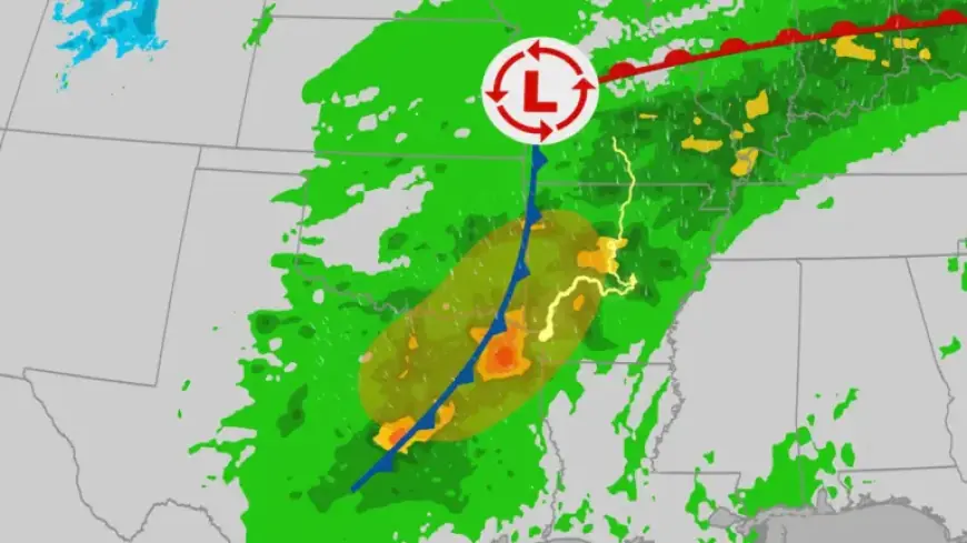
Severe Weather Forecast
Though it remains uncertain how severe the weather will be, forecasts indicate that severe storms, large hail, damaging winds, and the possibility of tornadoes are on the horizon.
Timeline of Events
- Tuesday Night: The threat of severe weather begins across the Southern Plains, particularly from Texas to Arkansas.
- Wednesday: The highest risk of severe weather occurs. The Storm Prediction Center (SPC) has issued a severe weather outlook for the area.
- Wednesday Night – Thursday Night: Severe weather risks continue, with potential impacts extending from southern Nebraska to Missouri and Arkansas.
Potentially Hit Cities
Key cities that could experience severe weather include:
- Dallas
- Texarkana
- Little Rock
Rainfall Expectations
Heavy rainfall is expected, with several areas likely to see accumulations of 1-3 inches, and some areas experiencing higher totals if storms persist over the same locations. The Weather Prediction Center has issued a level 1 out of 4 risk for heavy rainfall across parts of the Southern Plains, as well as the Mississippi and Ohio Valleys.
Causative Factors of Drought
The need for this rainfall is critical due to the enduring drought across the southern United States. A moderate La Niña event has contributed to the current dry conditions this winter. This phenomenon alters weather patterns significantly.
Understanding La Niña
La Niña occurs when trade winds intensify, pushing warm water to the Western Pacific and allowing cooler waters to surface in the East. This shift often results in warmer and drier conditions in the Southern U.S., exacerbating drought situations.
Conclusion
The upcoming storm system presents an opportunity for much-needed drought relief in the Southern Plains. As conditions evolve, residents should remain vigilant and stay informed about potential weather developments.