


Boulder Fire, boulder fire alerts and Colorado's shifting risks
An AI-driven emergency notification app sent multiple false alarms in the Boulder County area this week, including an alert about a boulder fire that did not occur; the errors coincided with a separate weather pattern that kept fire danger high across parts of Colorado. The combination of misread dispatch audio and strong winds with low humidity has prompted local agencies to change radio tactics and urge verification of automated alerts.
Boulder Fire and boulder fire false alerts
One false notification told residents in a nearby town that firefighters were battling a "commercial blaze" downtown after an AI app misinterpreted live radio traffic from a training exercise simulating a structure fire. A screenshot of that alert circulated online and drew quick correction from someone on scene who said nothing was happening.
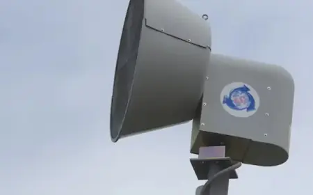
Officials from a local fire protection district noted that the incident stemmed from the app misreading dispatch audio tied to a training exercise. The district said it will shift future training to a tactical radio channel that is not publicly aired in an effort to prevent similar misinterpretations. It is unclear how the app had access to the channel used during the exercise.
Wind, low humidity and fire danger
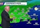
Statewide weather conditions were also elevating the risk of fast-moving fires. A red flag warning covered areas below 6, 000 feet from the Front Range foothills into the Eastern Plains, including the Denver metro area. The warning runs from 12: 00 p. m. ET through 8: 00 p. m. ET and calls for downslope wind gusts up to 55 mph, high temperatures in the 60s to low 70s, and relative humidity falling as low as 10 percent.
At the same time, heavy moisture is moving into the northern and central mountains, producing winter storm warnings and advisories. Some northern mountain zones could receive about a foot of snow or more with wind gusts reported up to 65+ mph. The mountain warning window spans from 7: 00 a. m. ET through 1: 00 a. m. ET, and avalanche danger in backcountry areas may reach a 4 out of 5 danger level during the heavy, wind-driven snow.
What agencies and residents should watch
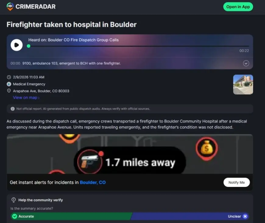
The AI app produced a mix of false and accurate posts: at one point it pushed roughly 60 incident summaries in a single area, some of which matched linked dispatch audio and others that were later removed. When dispatch audio was clear, an alert correctly described a fire in a highway median east of a nearby town. When audio was garbled or used shorthand terms, the app made errors—one summary mistook the term "fire rider, " used to describe a medic riding in an ambulance, for "firefighter" and said a firefighter had been taken to the hospital when no personnel had been injured.
Local fire officials emphasized that dispatch audio can be incomplete and unverified until crews reach a scene, and that scanner-based feeds often tell only part of an incident. If strong downslope winds and very low humidity persist during the red flag window, any new ignition could spread quickly; conversely, heavy mountain snow will continue to raise avalanche risk in backcountry terrain. Agencies are changing radio practices to limit public access to certain channels and are advising the public to confirm automated alerts through official local channels.
Key takeaways
- AI-driven alerting systems have produced false Boulder County-area notifications; local agencies will move some traffic to nonpublic tactical channels.
- Low humidity and strong winds (gusts up to 55 mph) create elevated fire danger in lower-elevation zones from 12: 00 p. m. ET to 8: 00 p. m. ET.
- Mountain regions face heavy, wind-driven snow, gusts up to 65+ mph, and avalanche danger up to 4 out of 5 from 7: 00 a. m. ET through 1: 00 a. m. ET.