


Curiosity Captures Mastcam Panorama of Mars Boxwork and Finds Mineral Nodules
A Mastcam panorama taken on Sept. 26, 2025, and returned from the 4, 671st Martian day of the mission shows extensive boxwork ridges on Mount Sharp; curiosity about those ridges is driving close-up study because they record groundwater and climatic change. The images and in-place measurements matter now because they tie surface textures visible from orbit to minerals and nodules found at ground level, shifting timelines for how long water persisted.
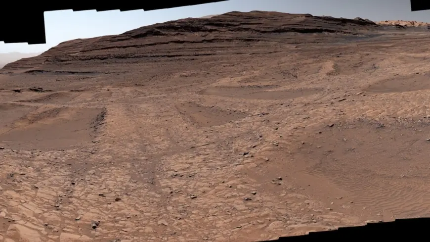
Curiosity’s Mastcam Panorama
The rover used Mastcam to collect 179 individual frames on Sept. 26, 2025, the mission's 4, 671st sol, and the frames were stitched into a single natural-color panorama intended to approximate how an average person would see the scene on Mars. Malin Space Science Systems in San Diego built and operates Mastcam. The panorama shows low, hardened ridges with hollows between them—features the mission team identifies as boxwork formations.
Boxwork Formations and Groundwater Evidence
Boxwork are low ridges with sandy hollows that, when viewed from above, resemble giant spiderwebs. Scientists trace their origin to water leaking into rock cracks billions of years ago; minerals carried by that water hardened inside fractures, and over eons windblown sand eroded the surrounding softer rock, leaving the mineralized ridges exposed. That sequence—groundwater depositing minerals, mineral hardening, and wind-driven erosion—creates a clear cause-and-effect chain linking ancient water flow to the present landscape.
Nodules Along Mount Sharp’s Ridges
Curiosity has spent the past six months traversing a region of delicate zigzag ridges and found small bumps, or nodules, in the area. These nodules appear along ridge walls and in the hollows between ridges rather than in the central fractures, and the team characterizes them as mineral deposits left behind as water dried up billions of years ago. The ridges on Mars are notably larger than typical terrestrial boxwork: roughly 3 to 6 feet (1 to 2 meters) tall, and they stand along the rover’s trail up Mount Sharp.
Mount Sharp Layers and Mission Timeline
Mount Sharp is about 3 miles tall (5 kilometers), and each layer of the mountain formed during a different era of Mars’s changing climate. As Curiosity climbs higher, measurements show a trend in which water became less persistent over time, punctuated by occasional wet episodes that suggest rivers and lakes returned intermittently. The rover will continue exploring the ridges until sometime in March before moving to a different region on Mount Sharp.
Jet Propulsion Laboratory, Caltech and Rover Operations
Curiosity was built by the Jet Propulsion Laboratory, which is managed by Caltech in Pasadena, California; JPL leads the mission on behalf of NASA’s Science Mission Directorate in Washington as part of the Mars Exploration Program portfolio. Operationally, the rover faced driving challenges: some ridges are not much wider than the SUV-sized Curiosity. Ashley Stroupe, an operations systems engineer at JPL, described the route as alternating between stretches that "almost feel like a highway" and hollows where wheels can slip or struggle to turn in sand, requiring different paths to find solutions.
Tina Seeger of Rice University in Houston is one of the mission scientists guiding the boxwork investigation. She notes that seeing boxwork this far up the mountain implies a relatively high groundwater table, which in turn means the presence of water needed to sustain life may have persisted longer than orbital data alone had suggested. "We can’t quite explain yet why the nodules appear where they do, " Seeger said, offering the possibility that ridges were cemented first and later groundwater episodes left nodules around them.
Orbital imagery provided initial clues about the spiderweb-like patterns, but driving to the ridges allowed the rover to reveal fine-scale structure and mineral textures. What makes this notable is the combination of a 179-image Mastcam panorama and in-situ nodules that together connect landscape-scale patterns to localized mineralogy, refining the timeline for groundwater activity on Mount Sharp.
Malin Space Science Systems’s Mastcam data, the rover’s ground observations, and the mission leadership structure—from JPL and Caltech to the Science Mission Directorate—are all part of the coordinated effort to map how water shaped this portion of Mars. NASA continues to emphasize exploration, innovation, and discovery as core objectives while Curiosity pursues these boxwork ridges, their nodules, and the story they tell about ancient Martian environments.