


Curiosity Surveys the Boxwork Region as curiosity Captures Panorama
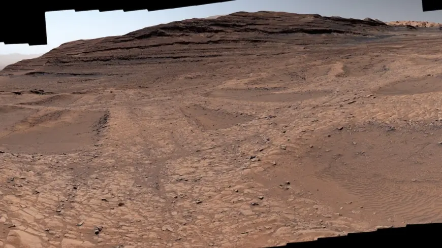
On Sept. 26, 2025, during the 4, 671st Martian day, or sol, the rover captured a stitched panorama of boxwork formations. The panorama, made from 179 individual images, presents a natural color view approximately how the scene would appear to an average person if they were on Mars, and curiosity continues to investigate the ridged terrain.
Curiosity Captures Boxwork Panorama
The panorama shows low ridges with hollows between them: boxwork formations created billions of years ago when water leaked through rock cracks and minerals carried into the cracks later hardened. After eons of windblown sand eroded the softer rock, the hardened ridges were left exposed. The 179 individual images were stitched together after being sent back to Earth.
Details of the Boxwork Formations
Scientists describe the ridges as hardened by minerals deposited where groundwater moved through cracks. Those minerals strengthened some areas and became ridges, while other parts without mineral reinforcement were eventually hollowed out by wind. From above, the pattern of hardened ridges and sandy hollows resembles a giant spiderweb, and Curiosity was able to drive up to the ridges to reveal what they look like up close.
Nodules and Groundwater Clues
The rover discovered small bumps in the nodules region that formed by minerals left behind as water on Mars dried up billions of years ago. The nodules were found along the ridge walls and in the hollows between them rather than in the central fractures. "We can’t quite explain yet why the nodules appear where they do, " Tina Seeger of Rice University in Houston, one of the mission scientists leading the boxwork investigation, said. "Maybe the ridges were cemented by minerals first, and later episodes of groundwater left nodules around them. "
Mount Sharp Context and Climate Layers
The boxwork formations were found along Curiosity’s trail up Mount Sharp. The ridges on Mars are approximately 3 to 6 feet (1 to 2 meters) tall, while similar formations on Earth are typically a few centimeters tall and found in caves or dry, sandy environments. Each layer of the 3-mile-tall (5-kilometer-tall) mountain formed in a different era of the planet’s changing climate. As the rover climbs higher on Mount Sharp, the data gathered show that water on Mars dried out over time, punctuated by occasional wet periods that suggest the return of rivers and lakes.
Driving Challenges on Narrow Ridges
Over the past six months, Curiosity has been carefully treading across a region filled with delicate zigzag ridges formed when groundwater deposited minerals in cracks that later hardened. The rover had a bumpy ride driving along the ridges, some of which were not much wider than the SUV-sized Curiosity itself. "It almost feels like a highway we can drive on. But then we have to go down into the hollows, where you need to be mindful of Curiosity’s wheels slipping or having trouble turning in the sand, " Ashley Stroupe, operations systems engineer at the Jet Propulsion Laboratory, said. "There’s always a solution. It just takes trying different paths. "
Engineering Credits and Mission Leadership
Curiosity was built by the Jet Propulsion Laboratory, which is managed by Caltech in Pasadena, California. The Jet Propulsion Laboratory leads the mission on behalf of the Science Mission Directorate in Washington as part of the Mars Exploration Program portfolio. The Mastcam that took the panorama was built and is operated by Malin Space Science Systems in San Diego.
Scientists believe groundwater once flowed through large fractures in the bedrock, leaving behind minerals that later hardened into ridges while wind removed the surrounding softer rock. Orbital imagery provided initial clues about the boxwork formations, and the rover’s close approach has offered direct observations that raise questions about the timing and duration of groundwater on Mars—questions tied to how long conditions suitable for sustaining life might have persisted. "Seeing boxwork this far up the mountain suggests the groundwater table had to be pretty high, " Tina Seeger said. "And that means the water needed for sustaining life could have lasted much longer than we thought looking from orbit. "
Curiosity will keep exploring the ridges until sometime in March before moving on to a different region on Mount Sharp. The original article text also included a subscription prompt inviting readers to "Subscribe and interact with our community, get up to date with our customised Newsletters and much more. " An incomplete sentence beginning "NASA has delayed the" appears in the provided text and is unclear in the provided context.
Closing: The vehicle’s Mastcam panorama from Sept. 26, 2025, and the rover’s up-close observations together document boxwork ridges, nodules, driving challenges, and groundwater clues on Mount Sharp, while mission teams and instruments named in the file continue the investigation.