


Tropical Cyclone Horacio: Earth’s first Category 5 tropical cyclone of 2026
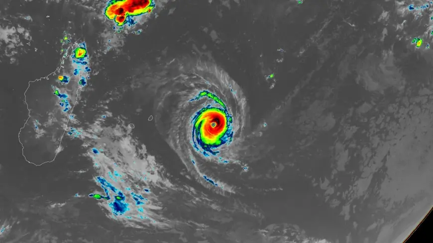
Tropical Cyclone Horacio became the world’s first Category 5 tropical cyclone of 2026 on Monday afternoon, February 23, reaching peak winds of 160 mph (260 km/h) over the remote South Indian Ocean. The milestone matters because it highlights how a set of environmental conditions can drive extreme intensification even in isolated waters.
Tropical Cyclone Horacio peak intensity and environment
Horacio reached Category 5 intensity while moving over sea surface temperatures measured at 27–28 degrees Celsius (81–82° F) and in a setting of moderate wind shear. These two factors together supported rapid strengthening to the 160 mph (260 km/h) peak recorded on February 23. The storm’s remote location in the South Indian Ocean left it isolated from land, limiting immediate threats to coastal populations.
Forecast trajectory and expected weakening
The Joint Typhoon Warning Center predicts that Horacio has peaked in intensity and will steadily weaken as it moves southward into cooler waters and a region with higher wind shear. That forecast frames the near-term outlook: the cyclone’s decrease in strength is expected to continue so long as the environmental trend toward cooler sea surface temperatures and stronger shear persists. Horacio remains far from any land areas and is a threat primarily to marine interests.
Rarity, recent context and what it signals
Horacio is the first Category 5 in the Southern Hemisphere since Cyclone Errol achieved that status off northwestern Australia on April 16, 2025. Historical averages and last year’s activity add context: the 1990–2025 average yearly number of Category 5 storms globally is 5. 3, and there were five Category 5 storms in 2025—three in the Atlantic, one in the Northwest Pacific, and one in the South Indian Ocean. Those 2025 storms were recorded as Hurricanes Melissa, Erin, and Humberto in the Atlantic; Typhoon Ragasa in the Northwest Pacific; and Cyclone Errol in the South Indian Ocean.
The emergence of Tropical Cyclone Horacio as a Category 5 event underscores a pattern noted in recent assessments: climate change is expected to increase the proportion of tropical cyclones that reach Category 4 and 5 strength. While Horacio was able to intensify under favorable local conditions, broader long-term shifts are expected to influence how often storms reach the highest intensity categories.
Practical implications and what comes next
Because Horacio is distant from land, immediate human impact in coastal areas is not expected; the primary concern is for vessels and marine operations in affected seas. Forecast models indicate steady weakening as the cyclone moves into less favorable waters, but monitoring will continue while Horacio remains an organized system. Recent updates indicate the storm’s intensity and trajectory could evolve, and forecasts will track any shifts in environmental conditions that might alter the weakening trend.
Tropical Cyclone Horacio’s rapid intensification to Category 5 status on February 23 stands as an early signal in the 2026 season: extreme tropical cyclone intensity remains possible when local oceanic and atmospheric conditions align, and such events fit into a wider context of recent Category 5 occurrences and expectations for future shifts in cyclone intensity patterns.