


Miami Weather: Sudden Cooldown, Dense Fog and Elevated Fire Risk Hit South Florida Communities
Miami Weather matters now because a fast-moving cold front will reshape conditions across South Florida within hours: dense interior fog this morning, a surge in afternoon showers, then a pronounced cooldown with much drier, windier air that raises fire concerns for drought-stricken coastal counties. Drivers, outdoor workers and fire-response planners are the earliest to feel the shift.
Miami Weather impacts first: visibility, travel and fire danger
Dense fog has developed across interior South Florida this morning and visibility may fall to a quarter mile or less in some spots. There is potential for that fog to drift closer to east coast metro areas before sunrise, so travel sensitivity is front-loaded: reduced speeds and extra following distance are advised until conditions improve shortly after sunrise as temperatures warm and winds increase.
Here’s the part that matters: the fog is the immediate hazard for morning commuters, but the larger concern is how the incoming cold front converts a warm, humid afternoon into much colder, drier conditions that create an elevated fire risk across the region.
The drought combined with stronger northwest winds behind the front has already pushed fire-threat indicators high. Red flag warnings are in effect across the Treasure Coast and Fire Weather Watches cover Palm Beach County and the remainder of South Florida. That means already-parched fuels plus gusty winds will increase the chance that any new ignition can spread quickly.
What the front will do and the surface-level timeline
A potent weather system diving southeast along the East Coast is sending a cold front into South Florida this afternoon into early evening. Ahead of the front a broken line of showers is expected to develop and move northwest to southeast, with rain chances rising during the afternoon as daytime heating peaks. Thunderstorms are not expected to be widespread, although an isolated storm cannot be ruled out near Lake Okeechobee and parts of northern coastal areas.
- This morning: dense interior fog, visibility possibly a quarter mile or less; risk of fog drifting toward east coast metro areas before sunrise.
- Afternoon into early evening: cold front moves through with a broken line of showers; isolated storm possible near Lake Okeechobee and some northern coastal spots.
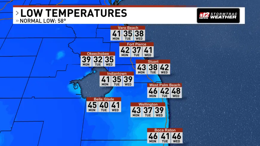
- Overnight into Monday–Wednesday mornings: strong high pressure building behind the front brings breezy northwest winds and much cooler mornings—east coast metro areas expected to stay in the 40s each morning while inland communities drop to the upper 30s.
Temperatures will fall sharply behind the front. With winds factored in, wind chill values will feel even colder. Monday afternoons will be much cooler, with highs in the lower 60s and very dry air as dewpoints drop into the 20s and 30s. Monday night into Tuesday morning is likely to be one of the coldest stretches, with another chilly start possible by Wednesday as highs remain below average until another front approaches late in the week.
It’s easy to overlook, but the combination of low dewpoints, gusty northwest winds and ongoing drought is what elevates the fire threat across coastal and inland zones, even though precipitation will increase briefly with the front.
- Dense morning fog across interior South Florida, potential drifting toward east coast metro areas.
- Afternoon showers with a broken line moving northwest to southeast; isolated storm possible near Lake Okeechobee.
- Sharp cool-down behind the front: mornings in the 40s along the coast and upper 30s inland; afternoons in the lower 60s through Tuesday.
- Drying air (dewpoints in the 20s–30s) plus breezy northwest winds create elevated fire risk; red flag warnings and Fire Weather Watches are active in parts of the region.
- Conditions should moderate late in the week as a subsequent front increases moisture and rain chances.
The real question now is how quickly the winds and low humidity behind the front test local fire resources and whether any ignition occurs during the driest, windiest hours. Emergency planners and residents in affected counties should treat current watches and warnings seriously and adjust outdoor activities accordingly.
The bigger signal here is that a rapid swing from near-record warmth to much cooler, drier air in a short span amplifies multiple hazards at once—fog and travel disruption first, then elevated fire risk and cold stress for vulnerable populations.