


Freeze Watch and Fire Weather Alerts Hit Central Florida Ahead of Arctic Blast
A freeze watch has been posted for parts of Central Florida as a cold front pushes through, bringing a brief period of showers followed by gusty winds, much drier air and a sharp drop in temperatures. The combination of sub-freezing pockets, dangerously low wind chills and fire-weather conditions has prompted multiple advisories and local impacts that matter for residents, visitors and outdoor operations this week.
National Weather Service issues Freeze Watch for Central Florida
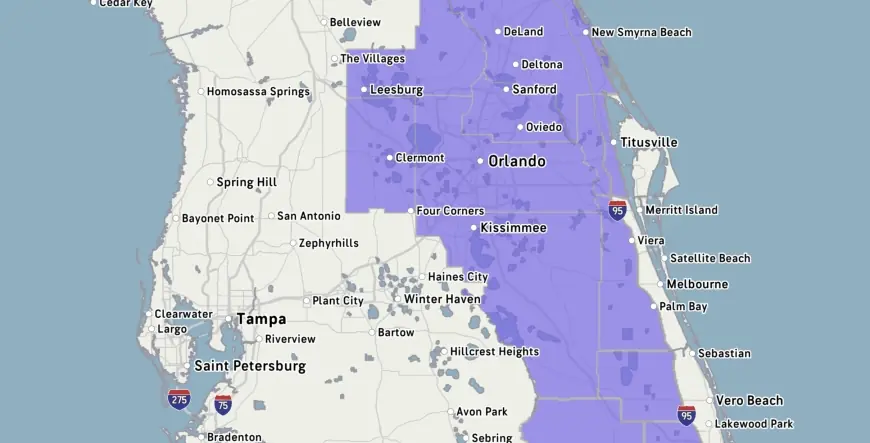
The National Weather Service has placed the region under multiple cold-weather products: a freeze warning covering a large swath of Central Florida for Tuesday from 3 a. m. to 9 a. m., and a separate Freeze Watch scheduled to take effect Monday night into Tuesday. The freeze warning's footprint explicitly includes Celebration, Orlando, Kissimmee, Oviedo and Clermont. During the period labeled a freeze watch, the NWS estimates sub-freezing temperatures as low as 30 degrees are possible.
Cold Weather Advisory set for early Monday as wind chills plunge
A Cold Weather Advisory runs from 3 a. m. to 9 a. m. Monday for dangerously cold feels-like temperatures. Forecasts call for Monday morning readings in the 30s and 40s with wind chills falling into the 20s and 30s; Tuesday morning looks even colder, with some spots waking up in the 20s and wind chills in the mid to upper 20s. The advisory follows a Sunday transition with temperatures still reaching the mid to upper 70s before the colder air arrives.
Cold front, gusty winds and Red Flag Warning trigger fire concerns
A cold front swinging through Sunday morning and pushing through by mid-afternoon will clear clouds from north to south, but it will also usher in gusty, very dry conditions. Those gusts combined with low humidity have produced a Red Flag Warning and a Fire Weather Watch for parts of the area, and officials have warned that it is not a good time for any outdoor burning. The same blustery winds will intensify wind chills, making daytime highs feel much colder than the thermometer indicates.
Cold timeline and temperature swing: when the chill arrives and how long it lasts
Showers associated with the front are expected to taper off around 1–2 p. m. Sunday, followed by cooler, breezy conditions. Sunday night temperatures will plummet into the middle to upper 30s with wind chills near or below freezing heading into Monday. Monday afternoon highs are forecast only in the lower to middle 50s, roughly 20 degrees below normal for this time of year, with afternoon values on Tuesday a touch warmer but still about 15 degrees below normal. The coldest stretch is Monday night into early Tuesday when many metro locations will have lows in the lower to middle 30s and northwest of Orlando could drop below freezing, with some spots in the upper 20s. The warming trend resumes mid- to late-week, with highs projected to return to the 80s by Thursday.
Local impacts: parks closed, counties under Freeze Watches and precautions urged
Precautionary measures are already visible: a major water park, Blizzard Beach, will be closed on both Monday and Tuesday this week, and area water parks have closed several times so far in 2026 because of the cold. Freeze Watches have been issued for specific counties including Marion, Sumter and Flagler, as well as for locales in Alachua, Levy and Gilchrist counties. Residents are advised to cover vulnerable plants and bring pets indoors during the overnight freeze threat. The area experienced a hard freeze at the end of January, underscoring the potential for damage this week.
Meteorological notes and public contact information
Meteorologist T. J. Springer provided a briefing on the pattern and timing on February 22, 2026; another local meteorologist, Michelle, joined the broadcast team in May 2023. For questions related to public files or station records, the listed contact number is 291-6000. One local station has also noted it is incorporating Artificial Intelligence technologies into its news gathering and presentation efforts.
What makes this notable is the juxtaposition of fire risk and freeze potential within a short window: very dry, windy conditions raise brush-fire danger even as Arctic air drives temperatures low enough to threaten plants, pets and outdoor attractions. The timing matters because the coldest conditions are concentrated overnight into the morning commute hours when impacts on travel, outdoor workers and vulnerable vegetation are greatest.