


Weather: Major blizzard bearing down on NYC, Tri-State area — weather warnings expanded
A major winter storm is rapidly intensifying just off the coast and the entire Tri-State area is now under a Blizzard Warning through 6 p. m. Monday, with snow already falling across New York City and temperatures dropping below freezing faster than expected. The weather setup is exceptionally rare: all 29 counties in the viewing area are included, something not seen since the Blizzard of 1996.
Weather impacts on travel
Roads that were wet and slushy this afternoon are expected to become snow-covered by evening, and travel will deteriorate rapidly tonight as the storm evolves into a full-blown blizzard. Overnight through Monday morning, wind gusts of 50 to 60 mph—especially along the coast—will combine with heavy snow to create dangerous conditions. The National Weather Service warned the storm could bring wind gusts up to 55 mph, creating whiteout conditions that "will make travel treacherous and potentially life-threatening. " Forecasters added that "strong winds, combined with the weight of heavy, wet snow, will likely result in scattered to numerous power outages. "
Blizzard warning through Monday evening
To qualify as a blizzard, conditions must include gusts over 35 mph, heavy snow, and visibility under a quarter-mile for at least three hours. Many parts of the region—even inland areas like Sussex, Poughkeepsie, and Newburgh—are likely to meet or exceed that threshold tonight into Monday. Some coastal communities may endure 12 to 16 consecutive hours of blizzard conditions.
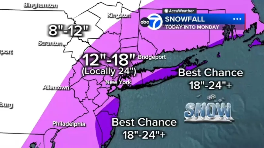
Snow totals and banding potential
The storm organizes and intensifies dramatically tonight, with the most intense snowfall likely from midnight through daybreak Monday. Embedded snow bands could produce 2 to 3 inch-per-hour rates, and any location stuck under one of these bands for several hours could quickly rack up totals near two feet or more. Two potential bands appear most likely to develop: one stretching from New Jersey into the Hudson Valley, and another from Long Island down to the Jersey Shore.
Wind, outages and coastal flooding
Officials expect power outages as heavy, wet snow weighs down trees and wires. Coastal flooding is a concern, particularly along the South Shore of Long Island and the Jersey Shore, where 2 to 3 feet of inundation is possible in vulnerable back-bay areas during high tide. Snow is expected to continue through Monday morning, remaining heavy at times—especially from the city eastward—before conditions finally begin easing midday and tapering to lighter bursts late afternoon and evening. Winds are forecast to remain strong well into Monday.
Air travel disruptions and cancellations
Thousands of flights have been canceled across the U. S. as the Northeast braces for the intense blizzard expected Sunday and Monday. The total number of disrupted flights reached more than 7, 000 as of 6 a. m., with 6, 456 U. S. flights canceled and an additional 547 U. S. flights delayed so far through Tuesday. Jetblue, American Airlines, Delta, Southwest and United have announced they will waive change and cancellation fees ahead of the looming storm at many major flight hubs.
NJ Transit suspensions and travel ban
Regional transit authorities have moved to limit movement: NJ Transit rail service will be suspended at 9 p. m., and the agency previously announced bus, light rail and access link services will be suspended beginning at 6 p. m. A travel ban will also take effect at 9 p. m. These steps follow broader warnings that the nor'easter is forecast to bring snow totals of over a foot to parts of the Northeast beginning Sunday.
Blizzard warnings are in place for New York City and the New Jersey coastline, while winter storm watches and warnings are in effect for Boston, Philadelphia, Washington, D. C., and Baltimore. The heaviest snow will begin to fall Sunday night, with potential snow totals Sunday night into Monday topping 18–24 inches in New York City, Philadelphia and Boston. Widespread 12–18 inches are expected across much of the region, with localized 18–24 plus inches in eastern Long Island, the South Shore of Nassau County, and parts of the Jersey Shore. Totals will be under 12 inches farther north and west—for example, Pike and Sullivan counties—where the storm's moisture will be less concentrated.
Images tied to winter preparations show maintenance crews clearing snow from a taxiway at LaGuardia Airport in New York City on Jan. 26, 2026, and travelers waiting for flights at John F. Kennedy International Airport in New York City on Nov. 18, 2025. The unfolding storm has already contributed to storm-related impacts elsewhere, including headlines noting a Tennessee man dies after suffering heart attack while shoveling snow, adding to the toll associated with these events.
Snow will remain heavy at times into Monday morning, ease by midday and taper late in the day, but strong winds and coastal flooding risks will continue. Officials urge residents to prepare for extended outages, difficult travel, and prolonged blizzard conditions in some coastal and downwind communities.