


Blizzard Warning: Major East Coast Storm Expected Sunday, Monday; NYC Area Could See Biggest Snow Since 2016
A Blizzard Warning is in effect across the Tri-State as a dangerous, potentially historic winter storm moves in later today, bringing blizzard conditions, heavy snow, damaging winds and coastal flooding. The storm is expected to rapidly intensify through the afternoon and peak overnight, and it could be the largest snow-maker to slam the region since the January 2016 event.
Blizzard Warning: who is affected and why it matters
Every county in the region is under a Blizzard Warning. The system is driven by energy from the Ohio Valley colliding with Gulf and ocean moisture, creating a coastal storm that almost resembles a winter hurricane. That setup will pull up the East Coast and tap into just enough cold air to flip rain to snow across New York City and New Jersey by midday. The combination of heavy snow, coastal gusts and tidal surges creates simultaneous hazards: extreme travel impacts, whiteout visibility and power outage risk from downed trees and lines.
Current conditions across the Tri-State and nearby counties
This morning began with a light mix across the region. Light snow is falling across Sullivan, Ulster, Dutchess and Orange counties and parts of northwest New Jersey, while most of New Jersey is seeing rain early. Some sleet mixed in around Ocean County before transitioning to rain. Roads are wet to start, which may delay initial snow accumulation, but that delay is expected to be short-lived. Visibility is already reduced in spots, with White Plains down to 0. 2 miles; travel is expected to grow increasingly difficult as heavier snow organizes later today.
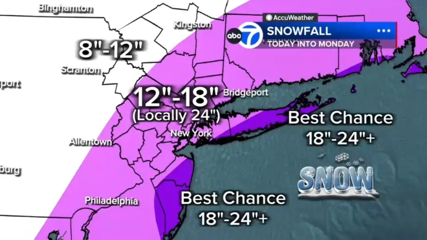
Snow totals and where the heaviest bands are expected
With hours of heavy snow overnight, totals will pile up quickly across the region:
- 12 to 18 inches across most of the region
- Localized 18 to 24 inches in a central corridor from the Jersey Shore to Long Island
- Best chance for 24-plus inches: East End of Long Island and parts of the Jersey Shore
- Up to 12 inches north and west (Pike, Sullivan, Ulster counties)
Winds, snowfall rates, whiteouts and coastal flooding threat
Heavier bands are expected to develop by evening and conditions will deteriorate rapidly. Forecasters expect snowfall rates of 1 to 2 inches per hour, wind gusts of 50 to 60 mph near the coast, and whiteout visibility. There is widespread potential for power outages due to downed trees and lines. In addition, winds whipping off the ocean may push water inland; up to 3 feet of coastal inundation is possible around high-tide cycles tonight into Monday morning, especially along Long Island and the Jersey Shore.
Timing and what to expect through Monday
The storm timeline is expected to unfold as follows:
- This Morning: Light mix, mainly wet roads; visibility issues in spots.
- Afternoon: Rain changes to snow for NYC and New Jersey; snow intensity increases after lunchtime.
- Tonight (Worst Conditions): Widespread heavy snow with 1–2 inches per hour, 50–60 mph coastal gusts, blizzard conditions with near-zero visibility, and elevated power outage risk.
- Monday Morning: Heavy snow continues through early morning, improving by mid-morning; snow tapers in the second half of the day but winds remain strong and travel stays impacted.
Local impacts and official actions
Because this storm threatens widespread disruption, preparations are already underway. New York City public schools will have a full snow day tomorrow, Mayor Mamdani announces. Residents should expect significant travel disruption overnight and into Monday, especially in the corridor between the Jersey Shore and Long Island where the highest totals are likely.
Live updates are being issued and frequent situation updates are expected as the storm evolves. Details may change as the system intensifies and organizes; the timeline and impacts described here reflect the current assessment of this major East Coast storm expected Sunday and Monday.