


Snowfall Weather Forecast: Warnings, Travel Risks and Coastal Rain as Cold Snap Deepens
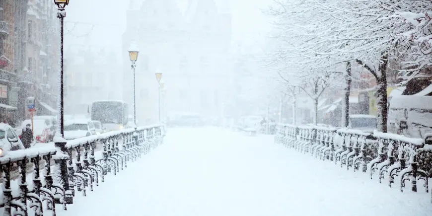
The Snowfall Weather Forecast outlines a run of yellow warnings for rain, snow and ice across the UK that could bring travel disruption, local flooding and power cuts as a cold snap continues. The sequence of frontal systems and strong winds means some areas should expect heavy rain totals, hill snow and icy conditions through Thursday.
Met Office warnings and UKHSA cold weather alert
National weather services have placed multiple yellow warnings in force, including a yellow warning for rain and snow that came into effect across Northern Ireland early on Wednesday morning and a separate yellow warning for rain covering southern parts of England. Yellow National Severe Weather Warnings remain in force until Thursday morning, while the UK Health Security Agency has issued a cold weather alert covering most of England until 18: 00 GMT on Friday. A further Met Office yellow warning for snow is due to begin later for parts of Wales, the Midlands and the southern Pennines, and an ice warning for Wales is scheduled to kick in during the evening.
Snowfall Weather Forecast for Wales
Wales faces a concentrated set of threats. A yellow warning affecting 18 counties lists Blaenau Gwent, Bridgend, Caerphilly, Carmarthenshire, Ceredigion, Conwy, Denbighshire, Gwynedd, Merthyr Tydfil, Monmouthshire, Neath Port Talbot, Newport, Pembrokeshire, Powys, Rhondda Cynon Taf, Swansea, Torfaen and Wrexham. Snow is expected in that area until 06: 00 GMT on Thursday, and a yellow warning for ice in the same area runs until 10: 00 on Thursday. Forecasters have warned of travel disruption and a small chance that some rural communities could become cut off; there is also a small chance of cuts to power and mobile service, with strong winds forecast. One warning suggested up to 15cm of snow could fall on the highest ground in mid and south-east Wales, while a separate advisory noted people living on higher ground in mid and southeast Wales could see up to 20cm of snow.
Northern Ireland and the Sperrins
Northern Ireland will see a mixture of wet and wintry weather throughout Wednesday, with persistent rain at low levels and snow over higher ground, particularly across the Sperrins. Across Northern Ireland a yellow warning covers rain falling as snow above 250 metres, where several centimetres could accumulate; lower levels are likely to see little or no lying snow, and any lying snow should thaw during the evening and overnight. Strong southeasterly winds are expected to accompany the wintry mix.
Southern England, Dartmoor and coastal impacts
Frontal systems will bring heavy rain to southern England through Wednesday into Thursday. Many areas are expected to see 10–20 mm, with 20–30 mm possible along the south coast and up to 50 mm across Dartmoor. In the wettest locations totals of 30–50 mm are possible, raising the risk of worsening flooding for areas already affected earlier in 2026. Strong east to northeasterly winds will accompany the rain and large waves may affect some east-facing coasts, particularly along the English Channel.
High ground, hill snow and wider chill
As the rain shifts northwards into Wales, the west Midlands and northern England later on Wednesday, some precipitation is expected to turn to snow over higher ground. Several centimetres of accumulation are likely above roughly 150–200 metres, with forecasts indicating 2–5 cm above those heights and 10–15 cm possible above 250–300 metres across mid and southeast Wales, Herefordshire, Shropshire and the southern Pennines. Small amounts, generally less than 2 cm, may fall at lower levels. Some snow could also start to affect the Peak District, the Pennines and possibly south-west Scotland during the night. North-westerly winds that drove a recent drop in temperatures left parts of north-east Scotland with readings below -9C (16F) on Tuesday night, and many northern and central areas saw a frosty start on Wednesday.
Transport notices, Network Rail and other disruption risks
Travel disruption is a realistic possibility: forecasters expect a small chance of delays on roads because of stranded vehicles and delays to train and flight schedules. Wind gusts of 45–55 mph will add to the hazard, and the wet, wintry mix could mean difficult travelling conditions during Wednesday evening and overnight as well as possible power cuts. Separate transport notes in circulation mention an airline warning of major disruption after fog leaves aircraft "in the wrong place", and recall that part of the line between Ashford and Borough Green closed in 2021 after a landslip; that closure was explained as part of engineering works taking place over a school half-term break, with Network Rail offering a rational explanation. Elsewhere, Deputy Lyndon Farnham has called for Jersey and Guernsey to "find solutions" to inter-island travel.
As the system clears on Thursday most areas are expected to turn drier, although Northern Ireland and western Scotland will see cloud and rain increasing by the afternoon. Temperatures are forecast to remain below average while ice warnings remain possible overnight, before Atlantic air pushes temperatures higher into the weekend with potential highs of up to 16°C in sheltered places. What makes this notable is the rapid swing from sub-zero nights—below -9C in places—to a forecast that could bring double-digit highs in sheltered spots within days, a combination that will complicate travel and flood risk management. Forecasters urge people to monitor the evolving warnings and local hour-by-hour forecasts on official weather channels and apps.