


Snowfall Weather Forecast: Snow and Rain Warnings in Force as Cold Snap Continues
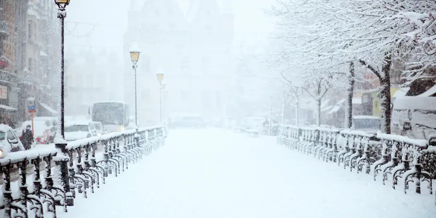
The Snowfall Weather Forecast for the UK shows multiple yellow warnings for rain, snow and ice as a cold snap brings heavy precipitation, strong winds and a real risk of travel disruption and flooding. The picture spans from wintry scenes in Aberdeenshire to targeted warnings across Northern Ireland, Wales and southern England.
Current warnings and where they apply
Yellow warnings are in force for rain and snow across Northern Ireland, and for heavy rain across southern parts of England. Another yellow warning for snow is due to begin later across parts of Wales, the Midlands and the southern Pennines, while an ice warning for Wales kicks in during the evening. National-level yellow severe weather warnings remain in place through to Thursday morning.
Snowfall Weather Forecast: expected accumulations and elevations
Several centimetres of snow are expected to accumulate over high ground, above around 150–200 metres. There is the possibility of up to 15 cm over the highest ground of mid and south-east Wales, Herefordshire, Shropshire and the southern Pennines, while some forecasts note up to 20 cm on higher ground in mid and southeast Wales. Snowfall of 2–5 cm is likely above 150–200 metres in affected areas, with 10–15 cm possible above 250–300 metres across mid and southeast Wales, Herefordshire, Shropshire and the southern Pennines. Small amounts, generally less than 2 cm, may fall at lower levels, and a mix of rain and sleet is expected at lower elevations with some wet snow possible at times.
Rain totals, coastal impacts and wind
Southern counties of England are likely to see the heaviest rain. Many areas can expect 10–20 mm, with 20–30 mm possible along the south coast and up to 50 mm across Dartmoor. In the wettest locations, 30–50 mm (1. 2–2. 0 in) could fall, posing a threat to areas already affected by flooding earlier in 2026. Strong east to northeasterly winds accompany the rain, with gusts of 45–55 mph forming an extra hazard and large waves possible on some east-facing coasts.
Northern Ireland, hills and thaw timing
Northern Ireland will see a mixture of rain, sleet and hill snow, with persistent rain at low levels and snow over high ground, especially across the Sperrins. Several centimetres could accumulate above 250 metres in places. Lower levels are expected to see little or no lying snow and any lying snow should thaw during the evening and overnight as temperatures rise slightly.
Local impacts: travel, power and community risks
Travel disruption is possible across the affected areas. There is a small chance of delays on roads caused by stranded vehicles and a slight chance of impacts to train and flight schedules. The wintry mix could make travelling difficult on Wednesday evening and overnight, and there is a small chance of power cuts and mobile service interruptions in the event of heavy snow and strong winds. In Wales, yellow warnings affecting 18 counties mean some rural communities may become cut off and some higher-ground communities face significant accumulations.
- Wales: 18 counties under yellow warning include Blaenau Gwent, Bridgend, Caerphilly, Carmarthenshire, Ceredigion, Conwy, Denbighshire, Gwynedd, Merthyr Tydfil, Monmouthshire, Neath Port Talbot, Newport, Pembrokeshire, Powys, Rhondda Cynon Taf, Swansea, Torfaen and Wrexham.
- Wales timing: snow expected until 06: 00 GMT on Thursday; an ice warning in the same area remains until 10: 00 on Thursday.
Broader outlook and uncertainty
North-westerly winds have already driven temperatures down in recent days, with temperatures dipping below -9°C (16°F) in parts of north‑east Scotland on Tuesday night and many northern and central areas seeing a frosty start to Wednesday. Cloud amounts are increasing from the south and west as frontal systems push rain and snow northwards. There remains some uncertainty in the forecast, so updates may change the detail of warnings and timings.
What clears next and longer-term expectations
As the system clears on Thursday, most areas are expected to turn drier. Northern Ireland and western Scotland will see cloud and rain increasing by the afternoon, and with temperatures still below average further ice warnings overnight remain possible. The outlook into the weekend stays unsettled with further bands of rain and brighter intervals; western areas will be most affected. Temperatures should become increasingly mild for the time of year if Atlantic air moves in, with the potential for highs up to 16°C in sheltered places where there is some brightness before conditions return closer to average into next week.
Local operational notes and community items
Separately, a local rail closure is explained as part of engineering works taking place over the school half-term break, an explanation that some found more prosaic than dramatic. Deputy Lyndon Farnham has urged Jersey and Guernsey to find solutions to inter-island travel. In an unrelated community grant, Vauvert School, the Sixth Form Centre and Ladies College have been awarded a shared grant of £3, 000. A city council has noted landscaping proposals that could see 49 new trees planted as part of a local project.
Forecast details are subject to change; keep prepared for warnings to evolve and for local updates to refine timings and impacts.