


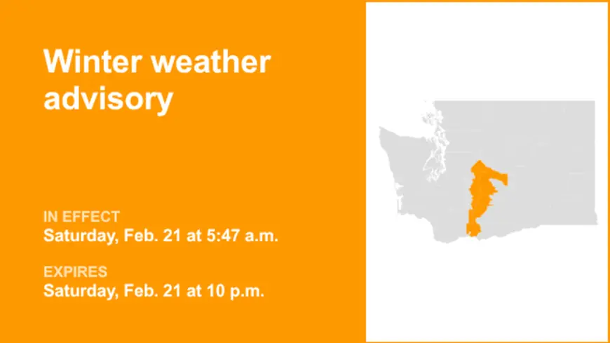
Winter Weather Advisory Explained: What It Means, How It Differs From a Winter Storm Warning, and What to Do Next
A winter weather advisory is the “take this seriously, but it’s not the top-tier alert” message in the winter storm toolbox. It’s issued when snow, sleet, freezing rain, or blowing snow is expected to create travel problems and day-to-day disruptions, but the forecast does not rise to the higher thresholds typically used for a winter storm warning or blizzard warning.
In practice, a winter weather advisory is the alert most likely to affect routine life: slippery roads for the morning commute, a quick coating that turns sidewalks into skating rinks, spotty icing on bridges, and visibility drops in bursts of snow. It’s also the alert that’s easiest to ignore—until the first crash, the first spinout, or the first untreated side street proves why it was posted.
What a Winter Weather Advisory means in plain English
A winter weather advisory signals that winter precipitation is likely to cause hazardous conditions, especially for travel, but the expected amounts and impacts are generally below the criteria used for a warning.
Key idea: advisories are impact-based as much as they are accumulation-based. A “modest” amount of snow can still be dangerous if it hits during rush hour, falls on warm pavement and refreezes overnight, or is paired with gusty winds that reduce visibility.
Common advisory setups include:
-
Several inches of snow that make roads slick and slow
-
Light freezing rain that produces glaze ice on elevated surfaces
-
Sleet that bounces, compacts, and turns roadways into a low-friction mess
-
Blowing snow that reduces visibility and creates drifting, even if totals are not extreme
Advisory vs. watch vs. warning: why the wording matters
These terms are about confidence and severity:
-
Watch: conditions are favorable for a significant winter event, but details are still uncertain.
-
Advisory: a winter event is expected to cause inconveniences and travel difficulties, but it’s not projected to reach the more severe warning criteria.
-
Warning: a higher-impact winter event is expected or occurring, with a greater chance of major travel hazards and widespread disruption.
The label changes how governments and businesses react. Schools, transit agencies, and employers often use the warning tier as a trigger for more aggressive decisions. Advisories can still warrant cancellations or delays, but they usually require more local judgment and real-time updates.
Behind the headline: why advisories can be more dangerous than people assume
A winter weather advisory often sits in the “gray zone,” where the meteorology is manageable but the real-world consequences aren’t. That’s because the most costly outcomes of winter weather—crashes, falls, and localized icing—don’t require huge totals.
The incentives also push people in the wrong direction:
-
Individuals try to “beat the storm,” adding more cars to roads right as conditions begin to deteriorate.
-
Businesses hesitate to change schedules without the stronger language of a warning.
-
Drivers underestimate freezing rain and sleet because it can look like “just a drizzle,” right up until tires lose grip.
Stakeholders with the most exposure include commuters, delivery drivers, transit riders, older adults at risk of falls, and anyone living in neighborhoods where secondary roads and sidewalks are cleared later.
Second-order effects can be outsized:
-
Emergency response times can slow even with moderate snow.
-
A light glaze can create scattered power issues if it coincides with wind, especially where branches are already stressed.
-
“Refreeze nights” can turn daytime slush into early-morning black ice.
What we still don’t know when an advisory is issued
An advisory is often posted when forecasters have enough confidence that impacts are likely, but not enough certainty to call for a warning. The remaining unknowns usually decide whether things stay manageable or get messy:
-
Exact precipitation type at street level (snow vs. sleet vs. freezing rain)
-
Temperature trends after sunset, which control refreezing
-
Timing of the heaviest burst relative to rush hour
-
Whether narrow bands of heavier snow develop and linger
-
Local treatment effectiveness (salt, brine, plowing cadence)
Those details can vary neighborhood to neighborhood, especially in dense urban areas with different elevations, heat retention from buildings, and traffic patterns.
What happens next: 5 realistic scenarios and the triggers
-
Advisory is upgraded to a warning
Trigger: Forecast totals or icing potential increases, or confidence rises that severe impacts will occur. -
Advisory is extended
Trigger: Light snow or icing persists longer than expected, or refreezing becomes the main hazard. -
Advisory is reduced or canceled
Trigger: Temperatures warm, precipitation shifts to rain, or expected totals trend lower. -
Impacts concentrate in a smaller area
Trigger: A sharp temperature gradient sets up, leaving one corridor icy while nearby areas stay mainly wet. -
The advisory verifies but still causes major disruption
Trigger: The event overlaps peak travel times, producing crashes and delays even without warning-level totals.
What to do during a Winter Weather Advisory
Treat an advisory as a planning signal, not background noise.
-
If you can shift travel, avoid the first hours of onset and the refreeze window after sunset.
-
Assume bridges, overpasses, and untreated side streets will be worse than main roads.
-
Walk like it’s icy even if it doesn’t look icy—falls are a top risk in advisory events.
-
Keep your phone charged and allow extra time for everything that involves transportation.
A winter weather advisory is a reminder that winter hazards are often about timing and surfaces, not just inches. If you adjust plans early, an advisory day can be inconvenient instead of dangerous.