


Blizzard Warning, Winter Storm Watch and Winter Storm Warning: Snow Storm Weather Forecast for NYC as Heavy Snow Targets Sunday Into Monday
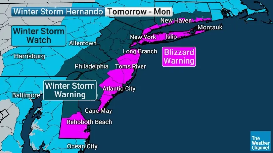
New York City is heading into a high-impact snow setup this weekend, with a blizzard warning in effect for the city area and a broader ring of winter storm warnings and watches across the region. The core risk is a long-duration burst of heavy snow paired with strong winds, a combination that can rapidly drive visibility to near-zero, snarl travel, and raise the odds of scattered power issues—especially closer to the coast.
Snow Storm Weather Forecast NYC: Timing, Intensity, and the Most Dangerous Window
The blizzard warning for New York City is set for Sunday at 6:00 AM ET through Monday at 6:00 PM ET. While snow may start lighter, conditions are expected to worsen through Sunday afternoon and turn most hazardous Sunday night into early Monday as snowfall rates ramp up and winds strengthen.
A practical way to think about the storm is in three phases:
-
Sunday morning to early afternoon ET: Snow develops or becomes steadier, with conditions slowly deteriorating.
-
Sunday late afternoon through Monday morning ET: Peak impacts. Expect periods of very heavy snow and strong winds, with the greatest risk of whiteout or near-whiteout conditions along and near the coast.
-
Monday midday to late afternoon ET: Snow tapers in intensity but blowing snow and difficult travel can linger, especially where drifts form.
The wind matters as much as the snow. When gusts rise and powdery snow is falling or already on the ground, visibility can collapse quickly even if snowfall rates briefly ease.
How Much Snow on Sunday in NYC, and What About Sunday Night?
Many people are asking, “How much snow on Sunday?” The most meaningful accumulation in the city is expected to build late Sunday and Sunday night, when temperatures drop enough for snow to stick more efficiently and the storm’s strongest dynamics arrive.
For NYC overall, storm totals around 6 to 12 inches remain a reasonable planning range, with locally higher totals possible in parts of the city if the heaviest banding sets up overhead for several hours. Amounts are expected to trend higher east and south of the city, including Long Island and coastal sections nearby, where totals well above a foot are more plausible.
If you’re trying to plan a specific Sunday schedule, the key takeaway is this: Sunday daytime may look manageable for a while in spots, but travel conditions can deteriorate sharply after sunset as heavier snow and stronger winds arrive.
Blizzard Warning NYC: What It Signals Beyond “A Lot of Snow”
A blizzard warning is not just about inches. It highlights the combination of heavy snow, sustained or gusty winds, and dangerously low visibility for an extended period. In practical terms, that means:
-
Roads can become impassable quickly, even after plowing begins.
-
Near-coastal neighborhoods can see the worst visibility and drifting.
-
Transit and flight disruptions become more likely as conditions peak.
-
Even short trips can turn risky if visibility collapses or vehicles get stuck.
NJ Weather and the Wider Region: Why Some Places Get More Than the City
In New Jersey, impacts depend heavily on location. Coastal and southern areas can see stronger winds and higher totals, while inland spots may see slightly lower totals or more variability based on where the heaviest snow bands stall. Northeast New Jersey is positioned for significant impacts, including difficult Sunday night travel and a rough Monday commute.
This is a classic setup where small track shifts can change local totals meaningfully. The city can land in a relative minimum while nearby coastal zones get hammered, or a narrow band can park over one borough and overperform.
What’s Behind the Headline: The Stakes, Incentives, and Who’s Most Exposed
This storm is high-profile because it hits at the intersection of population density and timing. Sunday night into Monday morning is when the region’s transportation network is most vulnerable: airports, commuter corridors, and transit systems all face peak demand and limited tolerance for low visibility and rapid accumulation.
Stakeholders with the most exposure include:
-
Commuters and essential workers who can’t shift schedules easily
-
City sanitation and road crews trying to keep up with peak rates
-
Utilities, especially in coastal wind corridors where tree damage is more likely
-
Businesses balancing opening decisions with worker safety and liability
-
Emergency services facing slower response times in whiteout conditions
What We Still Don’t Know: The Missing Pieces That Will Decide the Final Story
Even with a blizzard warning posted, a few details can still swing outcomes:
-
Where the most intense snow bands set up Sunday night
-
How quickly temperatures drop and whether early snow is wetter or slushier
-
The exact corridor of strongest wind gusts and how much blowing snow follows
-
How much coastal flooding occurs around high tide and whether it complicates evacuations or road closures
What Happens Next: 5 Realistic Scenarios to Watch
-
Heaviest snow band stalls over NYC for several hours
Trigger: Persistent banding Sunday night.
Result: City totals surge into the low to mid teens, with widespread near-whiteout bursts. -
NYC lands near the lower end while Long Island and coastal zones peak
Trigger: The storm’s strongest core stays just east.
Result: NYC closer to the 6 to 10 inch zone, but coastal totals significantly higher with more drifting. -
Wind-driven disruptions outpace snowfall disruptions
Trigger: Stronger gusts align with fluffier snow.
Result: Visibility and drifting become the main hazard, extending impacts even after snow lightens. -
Monday commute takes the biggest hit
Trigger: Snow remains heavy into early Monday and tapers slowly.
Result: Widespread delays, cancellations, and difficult clearing operations. -
A faster taper reduces late Monday impacts
Trigger: The storm pulls away sooner than expected.
Result: Travel improves Monday afternoon, though side streets and drifts remain a problem.
Why It Matters: Practical Guidance for “Snow This Weekend” Decisions
If you have flexibility, the safest play is to avoid driving Sunday night through Monday morning ET. If you must travel, plan for rapid changes in conditions, bring a winter kit, and assume trips will take far longer than normal. For households, the highest-value prep is simple: charge devices, secure outdoor items, plan for delayed services, and be ready to stay put during the peak window.