


Baltimore Weather: Snow Expected Sunday as Models Diverge
The Baltimore region is facing a Sunday storm that is likely to bring accumulating snow in spots, raising concerns for a disruptive commute into Monday morning. The immediate focus is on an unusually wide range of model projections and a National Weather Service watch that spans parts of the mid-Atlantic.
Baltimore Weather — Development details
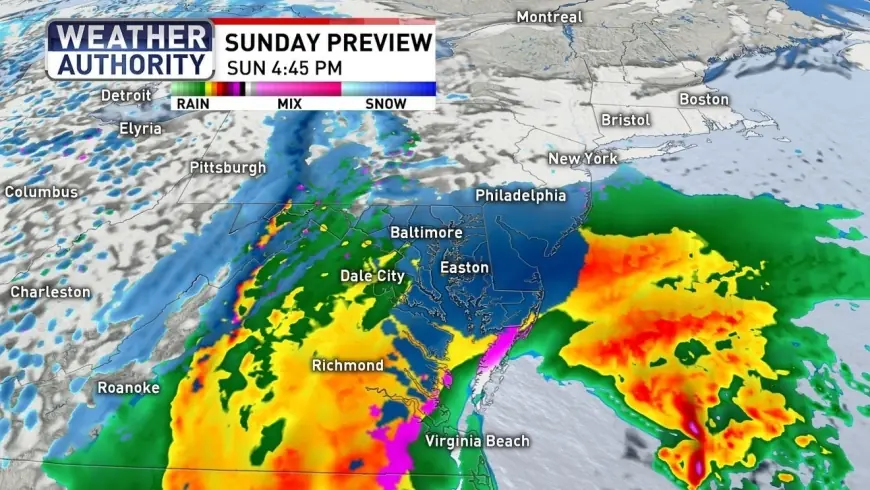
A sizable storm is projected to affect the area beginning Sunday, with the National Weather Service issuing a Winter Storm Watch for portions of the region. Forecast guidance diverges sharply: one global model shows a high-impact, low-confidence scenario with snowfall measures reaching up to two feet, while a prominent European model indicates a more modest event with accumulations up to six inches. A blended model set that combines many runs and observations currently centers near five inches.
At present, forecasts outline a broad range of possibilities, from as little as one inch to as much as two feet of snow. Most agencies assessing the situation identify a most-likely outcome of one to three inches, while noting pockets could see up to six inches where conditions favor sticking. Meteorological guidance also describes a transition from a chilly rain-snow mix early Sunday to a wetter, snow-dominant period by Sunday evening and into Monday morning, with the heaviest window late Sunday night into the early hours of Monday.
Context and pressure points
The divergence in model outcomes stems from differing projections of the storm’s strength and coastal track, which in turn determine how far inland heavier snow bands will set up. Ground temperatures are expected to be relatively warm during the daytime Sunday because of recent rain and daytime readings in the 50s, limiting early-day accumulation to grassy and elevated surfaces. What makes this notable is the timing: most sticking is forecast to occur after sunset when surfaces cool and wet snow is more likely to adhere.
Advisories for the storm differ in their time spans. Some forecasts list the watch through late Sunday night for broad portions of the region, while advisories for specific counties extend through Monday afternoon. That reflects the localized nature of the risk, with northern and western suburbs having the greatest chance for higher totals.
Immediate impact
The immediate concern is travel disruption. The rain-to-snow transition and the prospect of below-freezing temperatures after the event mean delays are possible into Monday morning, with slick roads and lingering icy spots. For many residents monitoring baltimore weather, the warm ground during the day suggests initial stickage will be limited, but any accumulation after sunset could create hazardous commuting conditions.
Road treatment strategies already reflect that uncertainty. Plow and highway crews are postponing some pretreatment in places where forecast rain could wash away salt and brine applications, and officials advising that once snow begins and sticking is observed, motorists should avoid travel when possible to let crews clear major routes first.
Forward outlook
The highest chance for heavier snowfall is expected late Sunday night into the early Monday hours, with snow tapering off by sunrise Monday and gusty, colder air following. Confirmed watch periods remain in effect for the affected counties through the overnight window and into Monday in some advisories; residents should monitor National Weather Service updates for the latest watch boundaries and timing.
The timing matters because late-evening accumulation on warmer ground can quickly translate into a slick morning commute. The broader implication is that even a lower-end outcome — a few inches that fall and refreeze — could have outsized effects on travel and school and work schedules. For now, the matter remains under review by forecasters as model guidance continues to be refined ahead of the storm’s arrival.