


Capital Weather Gang: Winter Storm Watch Issued as Models Diverge on Weekend Snowstorm
A Winter Storm Watch has been issued for parts of the mid-Atlantic ahead of a system expected Sunday, and the capital weather gang framing of model disagreement matters because outcomes range from light slush to a high-impact snow event that would disrupt commutes.
Capital Weather Gang assessment: models show wide range of outcomes
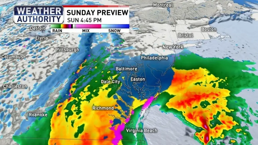
Forecast models disagree sharply on the strength and track of the system set to affect the region Sunday. One model shows a high-impact, low-confidence scenario with snowfall up to two feet. Another major model paints a more modest picture with accumulations up to 6 inches, while a blended model that updates frequently and combines many inputs is showing roughly 5 inches as the most statistically likely result. Across the model suite, outcomes span a wide envelope from about 1 inch up to 2 feet, with a consensus leaning toward a modest result in many areas.
What to expect from this weekend's snowstorm in Maryland and the DC area
Precipitation is expected to begin as a rain-snow mix early Sunday in the region, then transition to a wet snow by Sunday evening and into Monday morning. Daytime temperatures on Sunday are forecast to be in the mid-30s in the immediate D. C. area, which could limit sticking to grassy surfaces and higher elevations. Most accumulation is likely after sunset, when cooler air and cooler surfaces increase the potential for snow to stick.
For the D. C. region, maps show most areas in a 1–3 inch range as the central estimate, while locations north and west of the metro area could see higher totals, with some locales in line for 5 inches or more and isolated pockets where 6 inches could occur. Forecasters continue to flag uncertainty tied to a developing coastal storm off the Carolinas; small shifts in that coastal system's east-west placement would alter snow amounts across the mid-Atlantic.
Impacts, timing and travel outlook
A Winter Storm Watch is in effect for parts of the region, with timing and coverage extending through late Sunday night into portions of Monday afternoon for some counties. Most of the concentration of stickage and the highest chance for heavier snowfall is expected late Sunday night into very early Monday morning, with snow tapering off by sunrise Monday in many places.
- Timing: Rain or rain-snow mix during Sunday daytime, changeover to wet snow Sunday evening and night.
- Expected accumulations: Central estimates are in the 1–3 inch range for many areas; localized higher amounts of 5–6 inches possible north/west of the core metro area; some models show much larger totals in isolated scenarios.
- Impacts: Slick roads and potential delays for Monday morning commutes where snow sticks and temperatures drop below freezing.
Road crews are delaying pretreatment in places where forecast rain could wash away treatments, meaning travelers should prepare for potentially tricky conditions if the snow begins to stick. Gusty winds and colder air are expected after the system passes, with a few lingering slick spots before gradual improvement.
The capital weather gang narrative centers on uncertainty: model guidance spans a broad spectrum, and the eventual impacts will hinge on small shifts in the storm's track and intensity. Recent model blends favor modest accumulations for many locations, but the potential for heavier snow remains in lower-probability scenarios. Residents should monitor updated forecasts and be ready for travel disruptions if heavier snow materializes.