


Daytona 500 Weather: Hot, Windy and Rain Likely to Hold Off — Severe Storm Threat Moves In After the Race
Race-day conditions at Daytona International Speedway look favorable for the Daytona 500, with temperatures in the 80s and breezy southerly winds. The main concern is a line of strong to severe thunderstorms expected to arrive after the race, bringing a risk of damaging gusts, heavy rain and isolated tornadoes Sunday night.
Race-day snapshot: heat and wind, but dry for the green flag
Trackside readings will be warm, with highs in the 80s across the Daytona area. Winds are forecast from the south-southwest at roughly 23–25 mph, creating a notably gusty environment for fans and teams alike. Despite the gusts, precipitation chances should remain low through the afternoon and into the evening, giving the event a strong shot at proceeding without weather interruptions.
Those attending should plan for sustained winds and frequent gusts while outdoors, and sun protection is recommended given the mild-to-warm temperatures. Race officials and crew members should account for crosswinds when making setup and pit decisions.
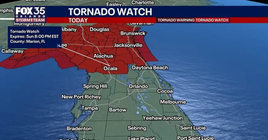
Severe storms expected after the race — timeline and threats
The primary weather threat will arrive after sunset. The heaviest storms are expected to move into Central Florida between 7: 00 p. m. and midnight ET. A tornado watch is in effect until 8: 00 p. m. ET for several counties north and west of the Daytona area, including parts of Alachua, Flagler, Marion and Gilchrist.
Storms that develop could produce damaging straight-line winds in the 45–55 mph range, with isolated gusts up to 60 mph possible. Heavy downpours and frequent lightning are likely in the stronger cells, and there remains a small chance that a brief tornado or two could form in the more volatile storms.
Risk levels vary by location: the Orlando metro is under a Level 1 risk for severe thunderstorms, areas north of Orlando sit under a higher Level 2 risk, and regions south of Orlando face a marginal threat. The greatest threats will be damaging winds and flooding from intense, slow-moving storms.
Short-term outlook: Monday and the week ahead
After the Sunday night storms push through, a slim chance of lingering showers remains as the workweek begins, but most communities should dry out for Monday, which is President's Day. Temperatures will drop modestly to the lower and middle 70s for Monday afternoon, offering a brief cooldown.
The cool-down will be short-lived. High pressure is forecast to build later in the week, ushering in sunnier skies and a warming trend. Afternoon highs are expected to climb back into the lower to middle 80s by mid- to late-week — roughly 10 degrees above average for this time of year — and that warmer pattern appears likely to hold into the following weekend.
Fans planning to remain in the area after the race should monitor changing conditions and be prepared to seek shelter if severe storms develop. Portable radios, mobile alerts and on-site announcers will provide the fastest updates for cancellations, delays or sheltering information.