


Tornado watch issued as Texas governor activates state emergency resources ahead of severe storms
State officials have mobilized emergency response resources as a potent storm system moves across Texas, prompting tornado watches, tornado warnings and widespread severe thunderstorm activity across much of the eastern two-thirds of the state. Residents are being urged to stay weather-aware, assemble emergency supplies and have a plan in case dangerous conditions develop.
State mobilizes emergency resources
The governor has directed the state emergency management division to activate response assets ahead of a system expected to begin impacting parts of Texas later Friday and continue through the weekend. The governor emphasized that the state is prepared to respond and urged Texans to monitor road conditions before traveling, remain aware of changing weather, and have an emergency plan in place.
Officials say a range of response capabilities is on standby to support local jurisdictions if needed. Emergency management teams are also monitoring an elevated wildfire risk across parts of South, West and Northwest Texas into next week, creating a dual concern for communities in the path of the system.
Storm threats and local impacts
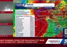
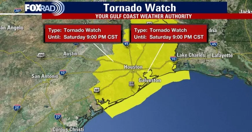
The National Weather Service warns the moving system can produce strong to severe thunderstorms, heavy rain, flash flooding, large hail, damaging winds and possible tornadoes. A tornado watch has been issued for numerous counties in the Houston-area and beyond, with some watches remaining in effect through 9: 00 p. m. ET on Saturday in select counties.
Several tornado warnings were issued Saturday evening for portions of the Greater Houston area. One warning covered parts of Brazoria, Harris and Galveston counties from 6: 50 p. m. ET to 7: 15 p. m. ET, with storm cells tracked moving east at roughly 40 mph. Local spotters and radar indicated areas of particular concern near Pearland and Rosharon, and storm damage was confirmed in parts of Pearland and Montgomery County.
Wind gusts up to 60 mph have been reported in the region, with the potential to cause damage to roofs, siding and trees. Severe thunderstorm warnings were issued across several counties at various times through the evening as the line of storms progressed southeastward. Forecast timelines showed the main window for the strongest storms beginning in the late afternoon northwest of Houston and sweeping into the Gulf by about 10: 00 p. m. ET.
What residents should do now
Officials are urging residents to take simple preparedness steps immediately: assemble an emergency supply kit, identify a safe shelter location in your home (an interior room on the lowest floor away from windows), and ensure cell phones are charged so alerts can be received. Motorists should check road conditions before travel and avoid driving through flooded roadways.
With watches and warnings likely to change as storms evolve, keep a battery-powered radio or weather app handy and follow guidance issued by local authorities. If a tornado warning is issued for your area, seek shelter immediately in a small interior room or storm-safe area and protect your head.
State and local emergency teams remain on alert and ready to respond to impacts. Residents should stay tuned to local forecasts and emergency communications through the evening and into the weekend as conditions develop.