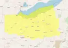


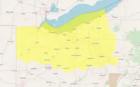


Moderate Snow and Ice Warning Escalates Winter Travel Risk as Arctic Air Pushes South
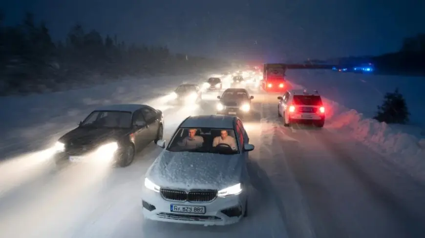
A moderate snow and ice warning is in effect as a fresh surge of Arctic air spreads wintry hazards across wide areas, raising the risk of slick roads, disrupted travel, and short-notice service delays from late Friday, February 13, 2026 ET into early Sunday, February 15, 2026 ET. The headline risk is not just snowfall totals, but the combination of rapid temperature drops, bursts of snow or sleet, and freezing rain that can turn untreated surfaces dangerous in minutes.
What the Moderate Snow and Ice Warning Means in Practical Terms
“Moderate” in winter weather messaging often signals a higher-likelihood event with impacts that are expected to be meaningful but uneven. That unevenness matters: one town can get mostly snow, while a nearby corridor sees a thin glaze of ice that causes the most crashes and power-line stress.
Key hazards typically tied to a moderate snow and ice warning include:
-
Quick-forming icy patches on bridges, overpasses, and shaded roads
-
Sudden reductions in visibility during heavier bursts
-
Slippery sidewalks and parking lots that increase fall injuries
-
Localized travel bottlenecks where a few miles make the difference between wet and frozen
Behind the Headline: Why This Pattern Causes Outsized Disruption
The disruptive power of snow and ice events comes from timing and surface conditions more than raw accumulation. When precipitation arrives near the freezing mark, small shifts in temperature and wind direction can flip rain to freezing rain or wet snow. That produces a “high-consequence, low-thickness” problem: only a thin layer of ice is needed to trigger pileups, flight delays, and widespread caution.
There is also a human factor. After stretches of milder weather, people assume roads will behave normally. That gap between expectation and reality is where accident rates jump, especially during the first commute after the warning begins.
Stakeholders and Incentives: Who Moves First, and Why
A moderate snow and ice warning sets off a familiar chain of decisions:
-
Local road crews must choose where limited salt and grit go first, prioritizing hills, major intersections, and hospital routes. The incentive is to prevent the first wave of crashes, because once vehicles are stuck, response times and plowing efficiency collapse.
-
Transit operators weigh preemptive slowdowns versus keeping schedules. Slowdowns reduce risk but can cascade into overcrowding and missed connections.
-
Power utilities watch ice risk closely, since freezing rain can add weight to lines and tree limbs. Their incentive is staging crews early, because restoration takes longer once roads are hazardous.
-
Schools and employers face the hardest call: close early and avoid risk, or wait for certainty and risk getting caught in worsening conditions.
What We Still Don’t Know
Even with a warning in place, several details can remain unsettled until the event is underway:
-
The exact rain versus freezing rain boundary, which can shift by a few miles
-
Whether the heaviest precipitation aligns with peak travel periods
-
How quickly temperatures fall after precipitation starts, determining refreeze risk overnight
-
Whether stronger wind gusts develop, which would raise drifting and visibility concerns
In short, the warning describes a risk envelope. The highest-impact outcome is usually tied to ice, not snow.
What Happens Next: 5 Realistic Scenarios and Their Triggers
-
Warning holds steady, impacts remain scattered
Trigger: temperatures hover close to freezing and precipitation stays light. -
Upgrade to a more severe warning for select corridors
Trigger: freezing rain becomes more likely or heavier bands set up over populated routes. -
Travel disruption spikes Saturday morning ET
Trigger: overnight refreeze plus early-day traffic before treatment is complete. -
Local power interruptions increase
Trigger: extended freezing rain or wet snow loading on trees and lines. -
Fast clearance, lingering “black ice” risk
Trigger: precipitation ends but skies clear, allowing rapid cooling and refreeze on damp pavement.
Why It Matters: The Second-Order Effects
Moderate snow and ice events are notorious for indirect fallout. Emergency rooms can see a rise in slip-and-fall injuries. Supply chains feel the pinch when deliveries are delayed by a few hours across multiple hubs. And reputationally, local authorities are judged less on forecasts and more on whether key routes were treated before conditions turned.
The next 48 hours will likely hinge on one question: does ice become widespread, or does precipitation fall mostly as manageable snow. Either way, the warning signals a period where small weather shifts can produce big real-world consequences.