


Dense fog advisory blankets Central West Florida through Friday morning; visibility near 1/4 mile
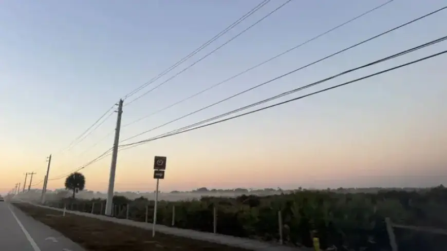
A dense fog advisory remains active across parts of Central West Florida into Friday morning ET, with visibility tumbling to a quarter-mile at times and creating hazardous travel for the early commute. Conditions are expected to improve by mid- to late morning as temperatures rise and light winds help disperse the fog.
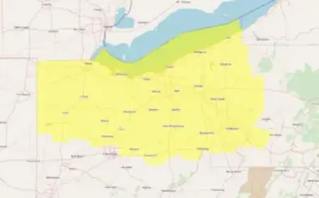
Where the advisory is in place
The advisory covers portions of Central West Florida, including the Tampa Bay area and nearby inland communities, where a widespread, shallow layer of saturated air developed overnight. The thickest fog has been pooling in low-lying areas, along river valleys, near marshes, and across open fields. Coastal neighborhoods and major corridors can also see rapid changes in visibility from one block to the next.
Farther southeast, patchy fog has formed in parts of interior South Florida. In some of those locations, an early-morning advisory has been posted through 7 a.m. ET. Fog is most common near sunrise, when temperatures bottom out and winds are lightest, allowing moisture to condense near the surface.
How low visibility may get
Drivers can expect visibility to drop to a quarter-mile or less in the denser pockets, particularly before and just after sunrise. Dense fog can reduce sightlines abruptly—clear roadways can transition to near-whiteout conditions within a few hundred feet, especially on bridges, overpasses, and rural stretches. The variability means motorists should be prepared for sudden slowdowns even if conditions initially look manageable.
Air travelers may experience minor delays during the early hours where instrument flight rules are in effect, though widespread disruptions are not guaranteed. Mariners operating near the coast and in bays should also plan for sharply reduced visibility over the water until the fog begins to lift.
Morning commute and safety guidance
Transportation officials urge extra caution for the Friday morning drive. Motorists should:
- Use low-beam headlights and fog lights if available; avoid high beams, which reflect off water droplets and worsen glare.
- Reduce speed and increase following distance to allow more time to react.
- Avoid sudden lane changes and use turn signals early to alert other drivers.
- Watch for pedestrians and bicyclists in poorly lit areas, especially near schools and bus stops.
- If visibility becomes too poor, pull off the roadway to a safe location, keep lights on, and use hazard flashers.
School zones and intersections can be particularly tricky in low visibility. Give buses, crosswalks, and merging traffic additional space. For boaters, sound signals and navigation lights are essential until sightlines improve.
Why the fog formed
Light winds, high humidity, and clear to partly clear skies overnight set the stage for classic radiation fog. The ground cooled quickly after sunset, chilling the thin layer of air closest to the surface until it reached saturation. In Central and South Florida, lingering moisture from earlier in the week and a weak boundary fading across the peninsula added to the setup. With little wind to mix the air, fog thickened in pockets and expanded toward sunrise.
These conditions are common during the cool season in Florida, particularly when high pressure builds nearby. Valleys, inland lakeshores, and open rural areas often see the earliest and most persistent fog under this pattern.
When conditions improve
As the sun climbs and temperatures inch up, the fog layer will begin to erode. Most locations under the advisory should see steady improvement from mid-morning onward Friday, with localized low clouds or haze lingering a bit longer in spots that start out the densest. By late morning to midday ET, general visibility should return to more typical levels across Central West Florida.
Any residual low clouds may hang back near the coast before yielding to brighter skies in the afternoon. Light winds trending easterly into Saturday will further limit widespread fog redevelopment Friday night, though patchy early-morning fog cannot be ruled out in favored inland areas.
Weekend weather at a glance
Beyond Friday morning’s fog, the region trends quiet and seasonable heading into the weekend. High pressure nearby favors mostly dry conditions with highs in the upper 70s to lower 80s and cooler nights inland. A developing storm system over the central U.S. will tug a cold front toward the peninsula late Sunday into Monday, bringing a better chance of scattered showers to start the new week. Widespread heavy rain looks unlikely at this stage, but coverage of light to moderate showers appears higher than earlier impulses this week. Behind the front, a drier, tranquil stretch should reestablish for the middle of next week.