


Cross-Polar Flow Intensifies: Expect Bitter Cold This Weekend
This winter, many are feeling the chill more intensely, and it could be linked to a phenomenon known as cross-polar flow. This weather pattern occurs when disturbances in the polar vortex send frigid air from Siberia down through North America.
Understanding Cross-Polar Flow
The polar vortex is a persistent area of low pressure located at the North Pole. It maintains a relatively circular shape, confining cold air to the Arctic region. When the polar vortex is stable, it limits the movement of this severe cold air.
The Role of High Pressure
However, when a blocking pattern forms due to high-pressure systems in areas like Alaska or the North Pacific, it can disrupt the polar vortex. This disruption allows extremely cold air to spill out from the Arctic Circle into the continental United States.
- Weather phenomenon: Cross-polar flow
- Origin of cold air: Siberia
- Disruptor: Blocking high-pressure systems
- Impact area: Across North America
Current Weather Impact
This winter’s disruptions have been particularly significant. They have resulted in longer periods of below-freezing temperatures across the U.S. Meteorologists predict that this trend will continue into the weekend.
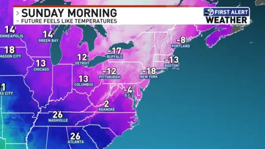
Forecast for the Weekend
As we move into Sunday, residents should prepare for bitter cold. Wind chill factors may enhance the severity of the cold, making it feel even colder than the actual temperature.
In summary, the intensified cross-polar flow this winter is leading to extreme cold conditions. It’s essential to take precautions, especially during the forecasted chilly days ahead.