


Warm Spell Next Week May Intensify Central U.S. Winter Storms
Next week, warmer air is expected to spread across a significant portion of the central and eastern United States. This shift may result in an increase in winter storm activity throughout the region. The current weather pattern has already exhibited moderately warm conditions in the western U.S. while the eastern states have been enduring periods of unusual cold.
Weather Pattern Changes Ahead
For the past few weeks, warm air has been concentrated in the western U.S. Conversely, an intense cold snap recently affected the eastern U.S., even reaching as far south as Florida. This past week saw temperatures in the eastern states begin to moderate, although many areas east of the Mississippi River remain below normal.
The warm air from the west is gradually pushing into the Plains. However, a fast-moving low-pressure system, known as a clipper, alongside an arctic blast, is forecasted to sweep through the Great Lakes and Northeast this Friday, maintaining chilly conditions in the eastern U.S. into early next week.
Upcoming Warmth and Storm Activity
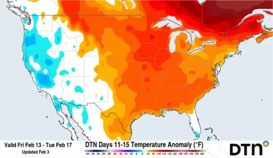
Next week marks a significant shift. The upper-level ridge stabilizing the warm air in the west will transition eastward, resulting in above-normal temperatures across most of the area east of the Rockies. This shift is anticipated to be most pronounced over the Plains and the Mississippi Valley.
While the warmth will provide relief from recent frigid temperatures, it may simultaneously trigger a more dynamic winter storm pattern. In such conditions, temperatures could still dip low enough for wintry precipitation.
Potential for Multiple Winter Storms
As the ridge moves, an upper-level trough is set to occupy the western U.S. This movement could unleash several storm systems across the country, beginning mid-February. Various factors will influence each system’s behavior:
- The temperature contrast surrounding the storm
- The availability of moisture from the Gulf
- The resistance posed by the eastern ridge
While predictions remain uncertain past a week, current patterns suggest a heightened potential for multiple winter storms, which may bring both heavy snow and rainfall, possibly even severe weather in some areas.
Comparison with Previous Storms
The upcoming storm patterns are expected to differ from those experienced during the late January storm. That event caused major disruptions across approximately two dozen states, bringing substantial snow and freezing rain, largely fueled by preceding arctic air. In contrast, any colder bursts expected now will likely derive from milder Pacific sources, reducing the chances of extreme cold.
The forecast for next week suggests that temperatures, while not as severe as late January, will still support ample snowfall. The Northern and Central Plains, as well as the Midwest and Northeast, pose the highest probability for snowfall in the coming weeks.
Key Dates for Winter Storms
The anticipated peak for winter storm activity is projected between February 10 and February 24, potentially stretching into early March. Although Punxsutawney Phil’s forecast for an extended winter may have missed the mark regarding temperature, he could still be astute concerning precipitation impacts.
As winter progresses, keeping an eye on these developments will be crucial for residents across the central and eastern U.S.