


Weather Alert: Snow Accumulation Predicted, 1-3 Inches Expected
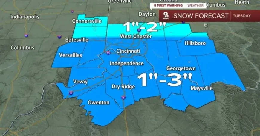
A weather alert has been issued for the Tri-State area, predicting light snow accumulation today. The expected snowfall amounts range from 1 to 3 inches, with some isolated areas potentially receiving up to 4 inches. This advisory may disrupt travel plans and daily activities.
Winter Weather Advisory Details
The National Weather Service has declared a Winter Weather Advisory effective from 7 a.m. to 10 p.m. today. This advisory aims to inform residents about the anticipated winter conditions and potential impacts on travel.
Snow Timeline and Movement
Snowfall is projected to begin early this morning, around 5 to 7 a.m., in northern regions. As the day progresses, the snow will gradually move southward, reaching central and southern areas by noon. By early afternoon, light snow should continue spreading southeast.
Afternoon Conditions
Temperatures during the afternoon will hover between 33°F and 35°F. Due to these warmer conditions, some snowfall may mix with rain, particularly in northern Kentucky. This will lead to wet conditions, which will hinder quick accumulation.
Evening Forecast
By approximately 8 p.m., all snow activity is expected to cease. The general consensus for total snowfall remains between 1 and 3 inches for most of the Tri-State area.
Weather Summary for the Week
- Tuesday: Snow likely with 1-3 inches expected; high of 33°F, low of 26°F.
- Tuesday Night: Mostly cloudy and colder; low of 15°F.
- Wednesday: Partly cloudy with a high around 27°F; feels like mid to upper teens.
- Wednesday Night: Few clouds with a low of 9°F.
To stay updated on the weather, residents can sign up for daily forecast emails from Filmogaz.com. Make sure to prepare accordingly as snow accumulation is predicted today.