


Record-Low Temperatures Trigger Freeze and Extreme Cold Warnings This Weekend
South Florida is bracing for an unprecedented cold spell as record-low temperatures are anticipated over the weekend. An arctic air mass is expected to sweep through the region, marking the coldest weather in over 16 years.
Significant Weather Changes Ahead
A strong cold front is moving into South Florida, bringing with it a range of weather conditions. On Saturday, gusty winds and early showers are forecasted, setting the stage for the cold air. The most severe cold will arrive on Sunday and Monday mornings, with daily record lows likely.
Wind Advisory and Gale Warnings
Expect gusty conditions through Saturday afternoon. Winds will reach up to 40 mph, prompting a Wind Advisory. A Gale Warning will also be in effect for coastal waters from 10 a.m. Saturday to 1 p.m. Sunday. Gusts in that period could reach 40 to 45 knots, with seas building to heights of 9 to 14 feet.
- Wind Advisory: Gusts up to 40 mph
- Gale Warning: Coastal waters (10 a.m. Saturday – 1 p.m. Sunday)
- Seas: 9-14 feet
Temperatures will peak in the lower 60s on Saturday, but the wind will create a much cooler feel. Residents are urged to secure outdoor items like patio furniture to prevent damage from the strong winds.
Extreme Cold and Freeze Warnings
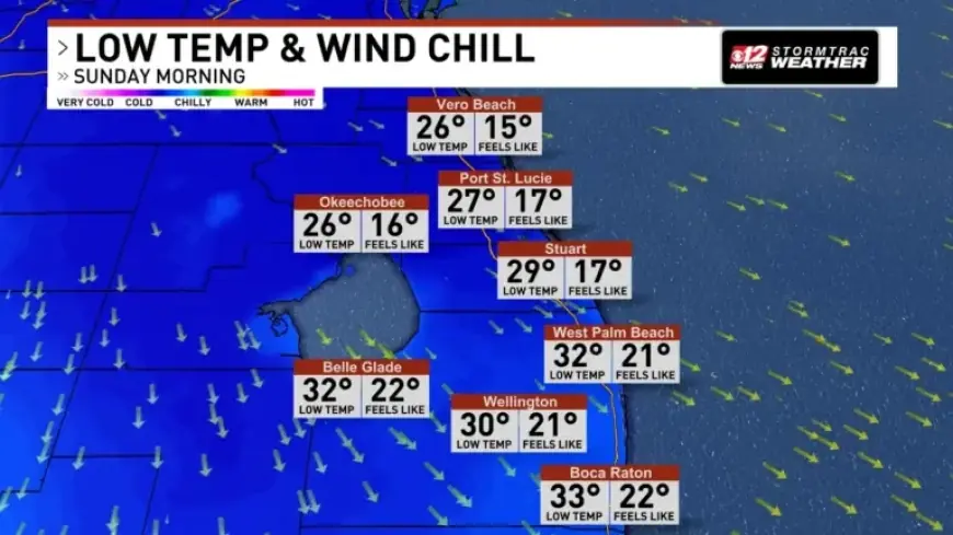
Several alerts are currently in effect due to the anticipated drop in temperatures. An Extreme Cold Warning is in place, with expected lows in the 20s for the Treasure Coast and 30s across Palm Beach County. Wind chills may fall into the teens and 20s.
- Extreme Cold Warning: Lows in the 20s, wind chills in the teens.
- Freeze Warning: Expect widespread frost and freezing conditions overnight.
Those with sensitive plants should take precautions, and pet owners are advised to bring pets indoors. Despite sunny weather, temperatures will only reach the 40s to low 50s on Sunday, accompanied by northwest winds of up to 25 mph.
Forecast for Early Next Week
Cold conditions will persist into Monday, with morning lows again dipping into the 20s along the Treasure Coast and middle 30s in the Palm Beaches. As winds diminish slightly, wind chills will more closely match actual temperatures.
The current cold wave will be followed by a dry air mass, dominating weather patterns through the weekend and early next week. By Wednesday, temperatures are expected to rise back into the 70s, although another cold front is anticipated to arrive on Thursday morning.