


Wind Advisory alerts expand as winter storm winds hit East Coast and parts of the West
A wind advisory is in effect across multiple parts of the U.S. heading into the weekend, as a powerful winter system drives strong gusts, blowing snow, and coastal impacts from the Southeast into the Mid-Atlantic, while Santa Ana winds elevate fire-weather and travel concerns in Southern California. The timing overlaps with dangerously cold air in several regions, increasing the risk of downed trees, power outages, and hazardous travel—especially where snow is falling or roads are already icy.
Even where snowfall totals stay modest, wind can turn a manageable forecast into a disruptive one by reducing visibility, drifting snow, and pushing coastal water into low-lying areas during high-tide cycles.
What’s driving the strongest gusts
Meteorologists are tracking a fast-intensifying coastal storm expected to strengthen rapidly offshore this weekend. The most severe wind impacts are forecast near the immediate coast—particularly across eastern sections of Georgia and the Carolinas into southern Virginia—before the storm’s core shifts north toward southern New England late Sunday into Monday (ET).
Peak conditions are expected Saturday night into early Sunday (ET) in parts of coastal North Carolina, where gusts could reach 70–80 mph. Farther north along the southern Virginia coast, gusts in the 35–50 mph range could combine with powdery snow to create near-whiteout bursts at times, even outside the most intense snowfall bands.
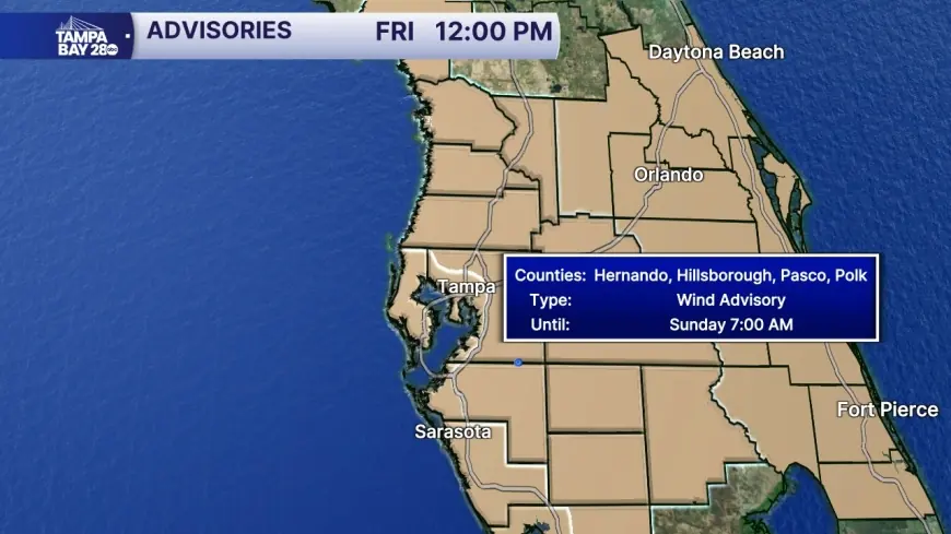
Wind Advisory: where it’s posted and when
Wind advisories are posted when gusts are strong enough to make driving difficult (especially for high-profile vehicles), bring down small limbs, and cause sporadic power interruptions—without necessarily meeting high wind warning criteria. Exact thresholds vary by local forecast office, terrain, and typical climate, so the same gust speed can carry different impacts in different places.
Here’s a snapshot of active or recently highlighted advisory windows and related wind expectations (times in ET):
| Area (example) | Advisory window (ET) | Wind detail (as forecast) |
|---|---|---|
| Southeast Virginia / coastal NC (Wakefield area) | Sat, Jan. 31, 7:00 p.m. to Sun, Feb. 1, 1:00 p.m. | Wind advisory posted alongside winter storm and cold hazards |
| Coastal Mid-Atlantic (Lower Eastern Shore example) | Late Sat night into Sun afternoon | Strong gusts expected to blow snow and reduce visibility |
| North & Central Georgia (Atlanta area briefing) | Sat morning through early Sun afternoon | Breezy period with gusts around 20–35 mph |
| Southern California wind-prone corridors | Through about 5:00 p.m. ET Friday | Gusts up to ~50 mph in favored passes and canyons |
Travel and power risks rise with cold and snow
Wind on its own can be a nuisance; wind paired with arctic air and snow can become dangerous quickly. In parts of the Southeast and southern Appalachians, cold air is entrenched enough that even light accumulations can stick to untreated roads. Add gusts, and visibility can drop suddenly as powdery snow lifts and drifts across highways and bridges.
Along the coast, the risk shifts from drifting snow to water and debris: strong onshore flow can push tides higher, toss sand and small objects onto roadways, and make travel treacherous on exposed causeways. Utilities also tend to see the most trouble where saturated ground or prior ice damage has weakened root systems—trees fall more easily when winds ramp up.
What to do during advisory conditions
Small steps can prevent the most common wind-related problems:
-
Secure lightweight outdoor items (trash bins, patio furniture, temporary signs).
-
Plan for brief outages: charge devices, keep flashlights ready, and avoid candles in windy conditions.
-
If driving, slow down and expect sudden crosswinds—especially on bridges, open interstates, and near high-rise gaps.
-
Treat blowing snow as a visibility event, not a snowfall event: if the road “disappears,” reduce speed immediately and increase following distance.
-
Near the coast, avoid parking in low-lying flood-prone spots during peak tide windows.
What to watch next
The next updates will hinge on the storm’s exact track and how quickly pressure falls offshore. A subtle shift east can reduce inland wind but intensify coastal gusts and surge; a shift west can expand the zone of travel impacts and extend the period of blowing snow. The most reliable near-term signals will be real-time wind observations, outage reports, and local warning upgrades if gust potential trends higher than expected.
For now, the key takeaway is simple: if you’re under an advisory, treat it as an impact forecast—plan for difficult driving, scattered disruptions, and quickly changing conditions, especially from Saturday evening through Sunday (ET).
Sources consulted: National Weather Service; NOAA; Georgia Emergency Management and Homeland Security Agency; LAist; The Washington Post; McClatchy.


