


N.J. Weather: Snow Likely This Weekend as Forecasters Monitor Coastal Storm
New Jersey residents should prepare for a potential winter storm this weekend, with snow forecasted late Saturday into Sunday. The National Weather Service has identified an increased likelihood of impactful snow and wind along the East Coast. However, uncertainty remains regarding the storm’s specific track.
N.J. Weather: Snow Likely This Weekend
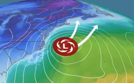
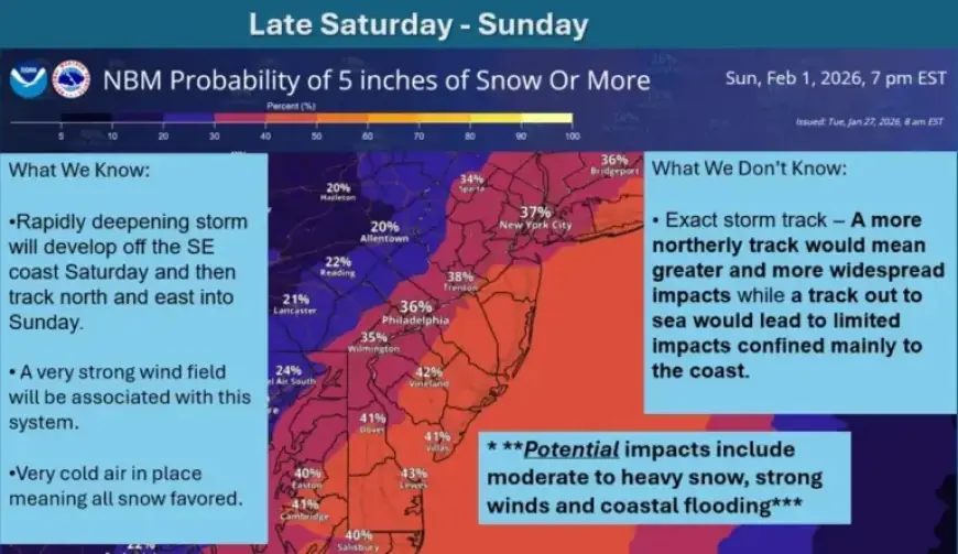
Forecasters are monitoring a coastal storm that may develop near the southeast coast by Saturday. This system’s trajectory is still uncertain, which makes predictions challenging. The storm could either veer out to sea with minimal effects or track closer to the coastline, increasing the chances for significant snowfall.
Snowfall Predictions
- 50% probability of snowfall greater than 4 inches along the Jersey Shore
- 40% probability for the I-95 corridor
- 20-25% probability for northwestern New Jersey
In addition to snowfall, strong winds are expected. The National Weather Service has noted that even if the storm remains offshore, coastal areas could still experience gusty winds. Cold air will dominate, creating conditions favorable for snowfall early in the storm.
Cold Temperatures and Wind Chill Advisory
Dangerously cold temperatures and wind chills below zero degrees will impact New Jersey through Friday. The National Weather Service warns that frostbite and hypothermia risks are significant with this exposure. A cold weather advisory remains in effect until 10 a.m. Wednesday.
Starting tonight and continuing into Wednesday morning, wind chills will range from zero to minus 10 degrees across most areas. Morning lows will dip into single digits, with highs only reaching the teens in the northwest and low to mid-20s elsewhere.
Extended Cold Forecast
An Arctic air mass will arrive with a cold front, bringing additional cold. Daytime highs will remain near the mid to upper teens in northern regions and around 20 degrees in South Jersey. Overnight lows from Wednesday through Friday are expected to fall into low single digits or below zero statewide. Wind chills could plunge as low as minus 20 degrees in areas northwest of the I-95 corridor.
The severe cold could strain energy infrastructure due to increased heating demands, and record low temperatures may be set later this week. The extended forecast indicates persistent cold conditions transitioning into the beginning of next week.