Extreme Cold Warning Reaches the Gulf Coast as a Nor’easter Threat Builds for Next Weekend Snow

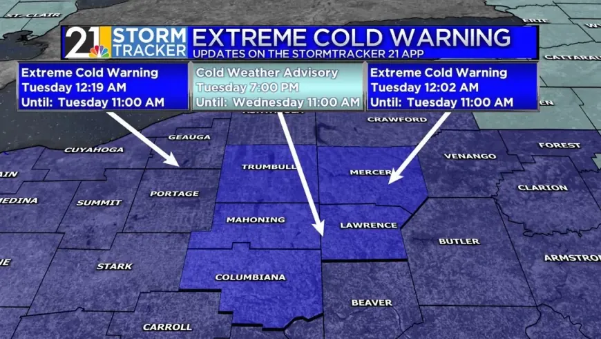
An extreme cold warning lingered into Tuesday morning, January 27, 2026, across parts of the Gulf Coast and the broader Southeast, underscoring how far south the arctic air has pressed after a sprawling winter storm. At the same time, forecasters are increasingly watching a potential nor’easter that could bring another round of snow and strong winds next weekend, with the highest-impact window currently centered on Saturday night, January 31, into Sunday, February 1 (ET).
The key takeaway is that the cold air is doing double duty: it is the immediate hazard for the Gulf Coast right now, and it is also the ingredient that could allow a coastal storm to produce snow farther south and heavier snow farther north—if the storm’s track cooperates.
What’s happening now: Extreme cold warning conditions on the Gulf Coast
Early Tuesday, wind chills and hard freezes were the dominant threat across parts of the Gulf Coast states, including areas near the central Gulf and the Florida Panhandle region. Some extreme cold warnings were set to expire by late morning Tuesday (ET), but the broader cold pattern remains in place, keeping overnight freezing temperatures in play and raising the risk of:
-
Burst pipes and damaged outdoor plumbing
-
Hazardous conditions for people without reliable heat
-
Stress on pets, livestock, and outdoor animals
-
Elevated fire risk from space heaters used improperly
For many Gulf Coast communities, the hazard is less about deep snow and more about duration: repeated nights below freezing can turn a brief cold snap into an infrastructure problem, especially where homes and pipes are not built for extended freezes.
Why this cold is so disruptive: it’s not just air temperature
Two things amplify impacts when the cold pushes this far south:
-
Wind plus cold equals faster danger. Wind chill accelerates heat loss and can turn “cold” into “dangerous” for anyone outdoors for prolonged periods.
-
The South is more sensitive to multi-night freezes. Water systems, road treatment capacity, shelter availability, and household heating setups often aren’t designed for repeated hard freezes.
That’s why the same temperature that’s routine in the Upper Midwest can be a serious public-safety event along the Gulf Coast.
Nor’easter watch: snow next weekend hinges on the storm track
Forecast guidance is increasingly aligned on a coastal storm developing near the Southeast and strengthening as it moves north along the Atlantic. The timing most often highlighted is late Saturday into Sunday (ET). A rapidly deepening storm offshore is the classic setup for a nor’easter—strong winds, rough surf, and a sharp precipitation gradient where small shifts in the track can mean the difference between heavy snow, mixed precipitation, cold rain, or even a near miss.
Right now, the most consistent “watch zone” runs from the eastern Carolinas northward through parts of the Mid-Atlantic and into southern New England. However, confidence in exact snowfall totals is still limited several days out, because the storm’s distance from the coastline will largely determine who gets the most intense banding and how far inland heavy snow can reach.
Behind the headline: why decision-makers are moving early
This is a high-stakes setup because it comes on the heels of a damaging, multi-state winter storm that already strained power restoration crews, road treatment resources, and emergency shelter capacity.
-
Utilities and public works face a tight turnaround: restoring service, repairing damage, and then preparing crews for another possible high-wind event along the coast.
-
Emergency managers are balancing fatigue and credibility: warn too early and people tune out; warn too late and people can’t prepare.
-
Transportation networks (air, road, rail, ports) are watching for cascading delays, especially if coastal winds and snow coincide with the weekend travel period.
-
Households and small businesses are the final mile of resilience: generator safety, heating plans, and protecting plumbing often determine whether a cold outbreak becomes a personal crisis.
What we still don’t know
Several missing pieces will determine whether “snow next weekend” becomes a widespread disruption or a narrower coastal event:
-
The storm’s closest approach to the coastline (a small shift can redraw the snow map)
-
How quickly cold air reloads behind the current arctic surge
-
Where the rain–snow line sets up, especially from the Mid-Atlantic into southern New England
-
Whether Gulf Coast wintry precipitation becomes more than isolated or brief late-week potential
What happens next: realistic scenarios and triggers (ET)
-
Scenario A: Offshore track (lower impact inland). If the low stays farther out to sea, snow and strong winds focus on immediate coastal areas, with inland cities seeing lighter totals or flurries.
-
Scenario B: “Closer coastal” track (higher snow/wind risk). If the low tucks closer to the coast Saturday night into Sunday, heavier snow bands can expand inland, and coastal wind impacts worsen.
-
Scenario C: Mixed-precipitation corridor expands. A slightly warmer coastal layer could push sleet/freezing rain into parts of the Mid-Atlantic while snow piles up farther north and inland.
-
Scenario D: Another Gulf Coast freeze wave dominates the story. Even if the nor’easter trends away, repeated hard freezes across the Gulf Coast can remain the primary impact through the weekend.
-
Scenario E: Prolonged cold extends into early next week. If snow and ice cover remain widespread, nighttime temperatures can stay suppressed longer than many forecasts initially suggest.
Why it matters, from the Gulf Coast to New England
For the Gulf Coast, the immediate risk is life safety during extreme cold and the cumulative damage from repeated freezes. For the East Coast, the next-weekend concern is a potentially fast-intensifying coastal storm that could combine snow, strong winds, and coastal flooding impacts—especially where cleanup and repairs are still underway from the last system.
In the near term, the most practical advice is straightforward: protect pipes, bring pets indoors, check on vulnerable neighbors, use heaters safely, and treat next weekend’s snow signal as a real possibility—but not a certainty—until the storm track becomes clearer later this week (ET).


