


Northeast Ohio Snow Forecast: Latest Timeline Revealed
A significant winter storm is set to impact Northeast Ohio, starting late Saturday. Snow accumulation and hazardous travel conditions are expected from Saturday night through Monday morning. The National Weather Service predicts that Sunday will experience the most severe effects of the storm.
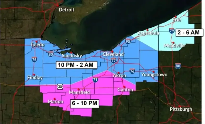
Northeast Ohio Snow Forecast Timeline
The snow will arrive in two main phases over the weekend. Here’s the expected timeline:
- 6 to 10 p.m. Saturday: Snow reaches southern Medina County and southern Summit County, moving into areas like Mansfield, Wooster, and Canton.
- 10 p.m. Saturday to 2 a.m. Sunday: Snow spreads into northern parts of Medina and Summit counties, covering all of Lorain, Cuyahoga, and most of Lake and Geauga counties, including Cleveland.
- 2 to 6 a.m. Sunday: Ashtabula County and northeastern segments of Lake and Geauga counties are expected to see snow, while southwestern Ashtabula County may receive snow earlier.
Weekend Weather Conditions
Snow will become widespread and steady Saturday night, leading to hazardous conditions on Sunday. The storm will peak in intensity on Sunday with moderate to heavy snowfall across the region.
Snow Accumulation and Travel Impact
Forecasts indicate that Northeast Ohio may receive between 8 to 11 inches of snow. Travel conditions are expected to deteriorate rapidly on Sunday morning, posing risks due to snow-covered roads and reduced visibility.
- Travel Advice: If travel is necessary, carry an emergency kit with a flashlight, food, and water.
- Monitoring Conditions: Check roadway and traffic updates at ohgo.com.
Snow may persist into Sunday night, tapering off gradually from west to east into Monday morning. Hazards from the storm are anticipated to linger into the Monday commute, even as snowfall decreases.