


N.J. Braces for Up to 18 Inches in Weekend Winter Storm Forecast
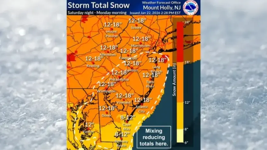
New Jersey is preparing for an intense winter storm this weekend that could bring between 12 to 18 inches of snow in many areas. The National Weather Service (NWS) has issued forecasts indicating widespread snowfall accumulation is likely, primarily across the northern and central parts of the state.
Winter Storm Forecast: Key Details
Forecasters are cautiously predicting snowfall amounts that range from 8 to 18 inches. The heaviest snow is expected to hit South Jersey on Sunday morning, with northern areas likely receiving significant totals by midday. Light snow showers or flurries might continue into Monday morning as the storm subsides.
Ice and Wintry Mix
In addition to snow, parts of southern New Jersey may experience a wintry mix, including a hazardous layer of ice. The NWS has warned of a light glaze, potentially reaching up to 0.10 inches in regions near and southeast of Interstate 95. This icing condition can make travel especially treacherous.
Timing and Preparation
The storm is expected to commence late Saturday night, combining energy from a system that has just formed off the California coast. This will merge with another system across the southern U.S. before intensifying off the Atlantic coast.
- Storm Start: Late Saturday night
- Snowfall Amounts: 12 to 18 inches in northern regions, 6 to 12 inches statewide
- Wintry Mix: Possible in southern New Jersey
- Ice Accumulation: Up to 0.10 inches near I-95
Warnings and Alerts
Winter storm watches are currently in effect for all 21 counties in New Jersey, starting from 7 p.m. Saturday. Additionally, cold weather alerts have been issued for dangerously low wind chills expected to range from zero degrees to 10 degrees below zero during Friday night and Saturday morning.
This extreme cold will heighten the risk of hypothermia and frostbite for those exposed to the elements without proper clothing. Safety officials are advising drivers to reconsider their weekend plans and avoid unnecessary travel on Sunday.
Post-Storm Conditions
Following the storm, temperatures are expected to remain well below normal, with wind chills dropping into the single digits. Continuing cold weather is forecasted to last through the following week.
Residents are encouraged to stay informed about evolving weather conditions as the winter storm approaches and to take necessary precautions to ensure their safety.