


Winter Storm Warning Risk Rises as a Major System Brings Snow, Ice, and Dangerous Travel Into the Weekend
A sprawling winter storm is tightening its grip on large parts of the United States, with winter storm warnings already active in some areas and a fast-expanding patchwork of winter storm watches posted ahead of the main event. The setup is classic and high-impact: cold Arctic air is entrenched across the interior while a moist storm system pushes in from the west, creating a wide corridor where heavy snow, sleet, and freezing rain can pile up quickly—often in the same region as temperatures wobble near freezing.
The result is a period where conditions can change hour by hour: a cold rain turns to ice, then flips to snow, while gusty winds reduce visibility and drift snow into roadways. Even where totals don’t look extreme on paper, ice is the wildcard that can turn routine travel into a shutdown and raise the odds of scattered power outages.
Where winter storm warnings and watches are expanding
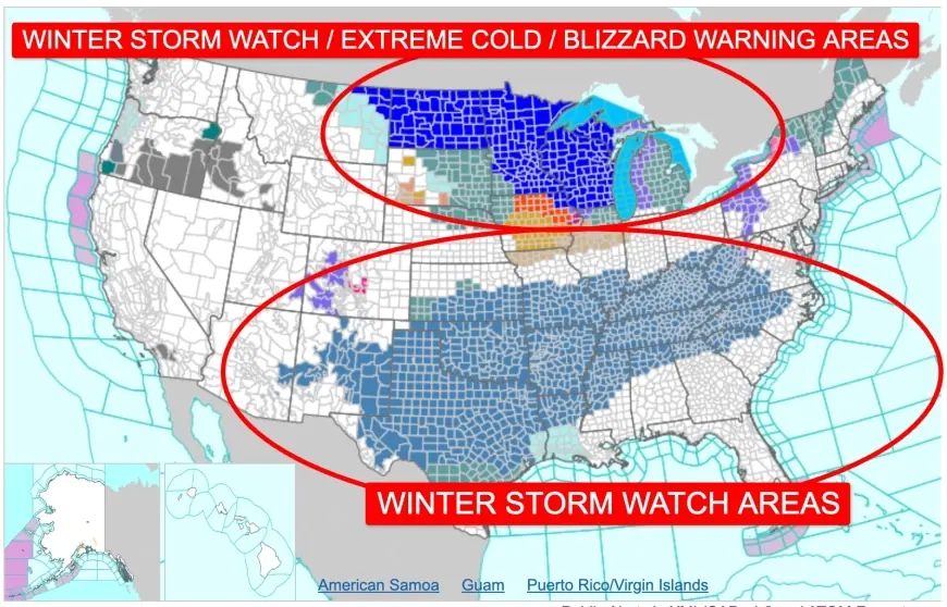
Forecast offices have been issuing winter storm watches for portions of the Mid-Atlantic and the southern Appalachians for the weekend into early next week, signaling growing confidence in disruptive winter weather but with details still sharpening. Separate alerts are also up across parts of the South and southern Plains where ice is the primary concern.
Here are some of the areas drawing the most attention as of Thursday, January 22, 2026:
-
Mid-Atlantic (including parts of Pennsylvania, Maryland, Virginia, and West Virginia): Winter storm watches are in place for the Saturday-to-Monday window in several areas, with the potential for significant snowfall totals where colder air holds.
-
Southern Appalachians and nearby foothills (parts of the Carolinas and northeast Georgia): Watches highlight the risk for mixed precipitation, with icing a major worry in addition to snow at higher elevations.
-
Texas Hill Country and the I-35 corridor north of San Antonio toward Austin: A watch emphasizes ice and sleet, with enough glaze possible to create hazardous roads and stress trees and power lines.
-
Great Lakes / Upper Midwest pockets: Some locations are dealing with higher-end wind-driven snow potential, including blizzard-type conditions in limited areas, while other spots remain in lighter advisory-level snow.
Because this is a large, long-duration storm, it’s not a single “hit-and-done” event. Many places will see a first wave late Friday into Saturday, a more intense period Saturday night into Sunday, then lingering impacts (including refreeze) into Monday morning.
Winter storm warning vs. winter storm watch: what it means for you
Winter alerts can feel like alphabet soup, but the difference matters:
| Alert | What it means | What to do now |
|---|---|---|
| Winter Storm Watch | Conditions are favorable for significant snow/ice, but timing/type/amounts can still shift | Prep plans, charge devices, adjust travel, watch updates closely |
| Winter Storm Warning | Significant winter weather is occurring or imminent (typically within ~36 hours) | Avoid unnecessary travel, finish last-minute prep, be ready for outages |
If you’re currently under a watch, treat it like a “go time” signal for preparation—because watches commonly upgrade to warnings as confidence increases.
The biggest hazards: ice first, then snow, then refreeze
Ice is often the most damaging part of these storms. A thin layer is enough to turn bridges into skating rinks; more can bring down tree limbs and power lines. Snow adds its own problems—especially if it’s heavy and wet (harder on trees/power lines) or if strong winds create near-whiteout conditions.
Even after precipitation ends, refreeze can extend danger into the next morning. Meltwater on roads re-ices overnight, and treated surfaces can lose effectiveness when temperatures plunge.
Timeline to watch (Eastern Time with rough Cairo reference)
-
Friday night (ET) / early Saturday (Cairo): Wintry precipitation begins spreading into parts of the southern Plains and lower Midwest; icing concerns start to ramp up in the South.
-
Saturday into Saturday night: Watches along the Appalachians and Mid-Atlantic become increasingly relevant as the storm expands east; heavier bands organize.
-
Sunday: Widespread impacts likely where snow/ice overlap; travel disruptions peak in many regions.
-
Late Sunday night into Monday morning: Snow tapers in the East, but refreeze and lingering slick spots remain a major issue.
What to do before the warning hits
If you’re in or near the watch/warning corridor, a small amount of prep goes a long way:
-
Travel: If you can avoid weekend driving, do. If you must drive, pack a winter kit (blanket, water, snacks, flashlight, phone charger, scraper).
-
Power: Charge phones and battery packs; set flashlights where you can find them fast; check backup heat plans safely.
-
Home: Bring in anything that can ice over or blow around; set faucets to a slow drip if hard freezes are expected and your plumbing is vulnerable.
-
Updates: Check local alert timing at least twice a day—morning and evening—because the rain/ice/snow line can shift dozens of miles.
What happens next
As the storm’s track and temperature profile sharpen, expect two key changes: watch areas expanding or shifting, and upgrades to winter storm warnings where confidence is highest. The most meaningful updates will focus on (1) where icing becomes the dominant hazard, and (2) where the heaviest snow bands set up and persist.
If you share your city and state (or nearest major metro), I can summarize the most likely precipitation type (snow vs. ice vs. mix), the most critical time window, and the practical impacts to expect.