


Snow Hits Wednesday, Dangerous Cold Friday, and Weekend Storm Threaten NE Ohio
Northeast Ohio is bracing for a series of winter weather threats over the upcoming days, including snow, extremely cold temperatures, and a potential winter storm. The first significant event is forecasted for Wednesday as a quick-moving weather system sweeps through the area.
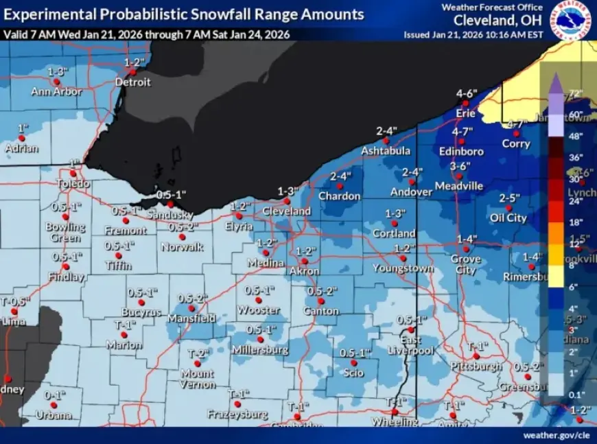
Snow Arrives Wednesday
On Wednesday, light snowfall is expected, particularly from the morning to early afternoon. While most locations will see accumulations of an inch or less, brief bursts of heavier snow could lead to slick road conditions.
Temperatures and Wind
Temperatures will be milder compared to previous days, predicted to reach the lower to mid-30s by the afternoon. However, winds are expected to pick up later in the evening, potentially reducing visibility during any lingering snow showers.
Brief Break Thursday
Snow showers will taper off by late Wednesday night, giving way to a quieter Thursday. A few leftover snow flurries may linger in the morning, but brighter conditions are probable in the afternoon. High temperatures will climb to the upper 20s to around 30 degrees.
Dangerous Cold Friday and Saturday
Friday marks a return to bitter Arctic temperatures. Forecasts indicate a significant drop throughout the day, with lows nearing 0 degrees. Wind chills may make it feel like between minus 10 and minus 20 degrees.
Impact of Arctic Front
- Temperatures will descend into the single digits by Friday night.
- Friday night will bring the coldest conditions, with wind chills persisting into Saturday.
- High temperatures on Saturday may struggle to reach the teens.
Weekend Storm Threat for Northeast Ohio
Attention is also turned to a large storm system developing in the southern United States this weekend. While the main impact zone will be to the south, Northeast Ohio could experience accumulating snow from late Saturday night into Sunday.
Forecast Updates
Recent forecast models suggest increased confidence for measurable snowfall in Northeast Ohio, particularly in areas east of Interstate 71. However, total accumulation amounts remain uncertain and will depend on the storm’s final trajectory.
Regardless of the storm’s path, well-below-average temperatures are anticipated to persist into early next week, marking a significant winter period for the region.