


Extreme Cold Watch Expands Across Parts of the U.S. as Arctic Air Targets Late Week and Weekend
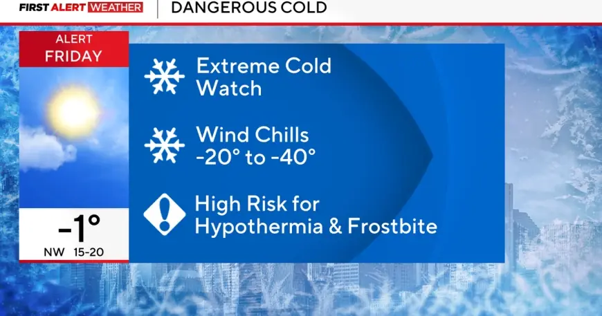
An Extreme Cold Watch is being issued in multiple regions as a fresh surge of Arctic air sets up a potentially dangerous stretch of wind chills from late Thursday into Saturday morning (January 22–24, 2026). The watch signals that life-threatening cold is possible, but the exact timing and worst-hit pockets can still shift—meaning communities are being urged to prepare now, before conditions firm up and alerts are upgraded.
What an Extreme Cold Watch Means Right Now
An Extreme Cold Watch is an early heads-up: extremely dangerous cold conditions or wind chill values are possible, but some details remain uncertain. In practical terms, it’s the “prepare” phase—often followed by an Extreme Cold Warning if confidence increases.
Even where actual air temperatures don’t look extraordinary at first glance, wind can drive wind chills to levels that can trigger frostbite quickly and raise hypothermia risk, especially for anyone outside for work, school commutes, or travel.
Where the Extreme Cold Watch Is Showing Up
The latest wave of watches is appearing across a wide slice of the country, with common timing that clusters around Thursday night into Saturday morning:
-
Upper Midwest: Large portions of the northern Plains and nearby states are bracing for the harshest wind chills, with some forecasts pointing to the most dangerous values in the region.
-
Great Lakes and Midwest metros: Watches are being posted around major population centers, where wind chills could plunge well below zero during the coldest window.
-
New England: Parts of the Northeast are also under watch for a deep freeze that could challenge records in the coldest inland areas.
-
South Central Texas: Farther south, watches highlight how unusual this air mass is—cold enough that wind chills could dip to or below zero in places not accustomed to that kind of exposure risk.
Because watch criteria can vary by local forecast office, the numbers won’t be identical everywhere. The consistent message is that the cold is expected to be sharp, wind-driven, and potentially hazardous.
Timing: When Conditions Could Turn Most Dangerous
Most watches emphasize a peak threat window from late Thursday night (January 22) through early Saturday (January 24), with the worst conditions typically occurring overnight into early morning hours. That’s when temperatures drop the fastest, winds can remain active, and exposure risk climbs—especially for anyone without adequate shelter or heating.
Forecast confidence often increases as the event gets closer. If the cold and wind track stays on target, many watches may be upgraded to warnings, sometimes within 12–24 hours of the expected peak.
Why This Cold Snap Is a Bigger Deal Than “Regular” Winter Cold
Two factors elevate this setup:
-
Wind chill impact: Wind can rapidly strip heat from exposed skin, creating frostbite risk in minutes at the lowest values.
-
Infrastructure strain: Sudden deep freezes can stress heating systems and power demand, and increase the risk of frozen or burst pipes—especially in areas where prolonged subfreezing spells are less common.
In southern areas, even “near-zero” wind chills can be disruptive because homes, plumbing, and outdoor infrastructure may not be designed for extended hard freezes.
Safety Checklist: What to Do Before the Cold Peaks
If you are in or near an Extreme Cold Watch area, the best time to act is before temperatures crash.
Personal safety
-
Limit time outdoors, especially overnight and early morning.
-
Dress in layers: insulated coat, hat, face covering, warm gloves or mittens, and waterproof boots.
-
Avoid sweating during outdoor work; moisture accelerates heat loss once you stop moving.
-
Check on neighbors, older adults, and anyone without reliable heat.
Home and pipes
-
Let indoor faucets drip during the coldest period if freezing is a known risk.
-
Open cabinet doors under sinks to circulate warm air (especially on exterior walls).
-
Bring sensitive items indoors: hoses, certain plants, and anything with water lines exposed.
-
Keep space heaters clear of clutter and never run them unattended.
Vehicles and travel
-
Keep the gas tank at least half full.
-
Pack a winter kit: blanket, gloves, charger, flashlight, and snacks.
-
Plan for slowdowns: cold can reduce tire pressure and battery performance.
Pets and livestock
-
Bring pets inside; provide windbreak and extra bedding for animals that must remain outdoors.
-
Ensure water sources don’t freeze over.
What to Watch for Next
The key update over the next day will be whether watches are upgraded to Extreme Cold Warnings as the highest-impact wind chills become more certain. Also watch for compounding hazards: light snow, ice, or blowing snow can worsen travel even if precipitation totals are minor.
For now, the takeaway is straightforward: an Extreme Cold Watch is the signal to prepare—because once wind chills drop into the dangerous range, problems escalate fast, and the margin for error outside gets very small.


