


National Weather Service issues wide-ranging winter alerts as Arctic air and a high-impact storm threaten travel and power
The National Weather Service is elevating winter messaging across a broad slice of the United States as two hazards converge: an expanding surge of Arctic air and a late-week storm expected to spread snow, sleet, and freezing rain from the Southern Plains into the Southeast and Mid-Atlantic. The most immediate risk is dangerous cold in the central U.S., while the biggest disruption potential builds Friday, January 23, through Sunday, January 25, when icing and heavy precipitation could create treacherous roads and scattered power outages.
The agency’s guidance is straightforward: plans should be flexible. Small changes in storm track and near-surface temperatures can quickly shift the most serious impacts from “heavy snow” to “damaging ice,” and the difference can be the deciding factor for travel safety and power reliability.
National Weather Service highlights: what’s changing between now and the weekend
The week is unfolding in phases. First comes the cold—pushing farther south and east—then the storm, drawing moisture north into that cold air and creating a long corridor where precipitation type will vary by region and even by neighborhood.
-
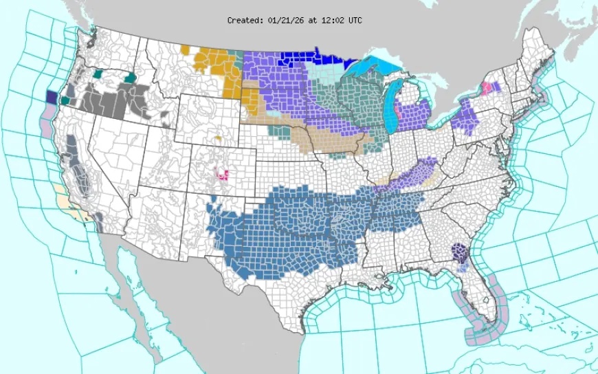
Dangerous wind chills expand from the Northern Plains into the Midwest, with the cold pushing toward the Ohio Valley and parts of the East later in the week.
-
Great Lakes snow remains a persistent hazard in the typical lake-effect corridors, with periodic visibility drops and fast-changing road conditions.
-
The highest-impact window for widespread disruption is Friday, January 23, through Sunday, January 25.
-
The greatest uncertainty is the “mix line,” where snow transitions to sleet or freezing rain; that boundary can shift with subtle temperature changes.
-
Ice accumulation is the main concern for power issues, while heavy snow and blowing snow are the main concerns for travel and visibility.
Why National Weather Service forecasts are emphasizing “ice vs snow”
In many winter storms, the headline is snowfall totals. This setup is more complicated. When temperatures hover near freezing, a shallow warm layer aloft can melt snow into rain, and then a cold surface layer can refreeze that rain on contact, producing glaze ice. That’s why the National Weather Service is putting extra attention on precipitation type, not just totals.
Ice is also a different kind of threat than snow. It turns roads into skating rinks quickly, and it adds weight to trees and power lines. Even a relatively thin coating can cause limbs to snap, lines to sag, and outages to cascade—especially when winds increase behind the storm.
Where the storm risk looks highest from January 23–25
The evolving pattern points to a broad swath of impacts from the Southern Plains into the Southeast and onward toward the Mid-Atlantic. In many areas, the highest risk may not be the heaviest precipitation—it may be the overlap of freezing temperatures with steady precipitation rates.
Communities most likely to see warnings change rapidly are those near the expected transition zone. If the cold air presses farther south than expected, more places see snow and sleet. If warmer air wins out at the surface, the freezing-rain zone can shrink—but if warm air rides over subfreezing ground, the icing risk can expand.
A key point for weekend planning: impacts often peak overnight and early morning, when temperatures are lowest and refreeze happens fastest. Roads that look merely wet at dusk can become hazardous by dawn.
What to do with National Weather Service alerts in real life
Winter weather alerts can feel noisy if you’re checking constantly, so it helps to translate them into action steps:
If you’re under a Winter Storm Watch:
Conditions are possible. Start adjusting travel plans, check vehicle readiness, and make a basic outage plan.
If you’re under a Winter Storm Warning or Ice Storm Warning:
Impacts are expected or imminent. Avoid unnecessary travel, prepare for rapidly worsening roads, and expect delays and closures.
If you’re under an Extreme Cold Warning or Wind Chill Warning:
Treat it like a safety event. Frostbite risk rises quickly, and exposed pipes, pets, and outdoor workers become vulnerable.
For families, a practical rule is to watch for the “stack”: winter precipitation plus subfreezing nights plus wind. When all three are present, even minor precipitation can become a significant hazard.
This kind of multi-hazard setup is not new. Past winters have shown that the most disruptive events in the central and eastern U.S. often involve a narrow corridor of ice on the warm side of a snow band, where impacts spread beyond roads into power, schools, and emergency response.
FAQ
How often will the National Weather Service update alerts?
As new data arrives, alerts can be adjusted multiple times a day, especially in transition zones where a few degrees change the outcome.
What’s the biggest mistake people make with winter alerts?
Waiting for a final “exact totals” forecast. In ice setups, the precise accumulation can be less important than timing, temperature, and whether precipitation is steady.
What should I prepare for first: snow or cold?
Cold is the earlier certainty in many places this week. The storm’s exact precipitation type may shift, but the cold increases refreeze risk and can complicate travel and repairs.
Over the next 48 hours, the signals that matter most are the southward reach of subfreezing air and where forecasters place the snow-to-ice transition corridor. If that boundary shifts, local impacts can change quickly—so the best approach is to check updates by place and by time, not just by region-wide headlines.


