


The Weather Channel warns of a major winter storm this weekend as ice, heavy snow and dangerous cold spread from the South to the East
A major winter storm is shaping up for this weekend, and The Weather Channel’s latest outlook points to a high-impact mix of freezing rain, sleet and snow stretching from parts of the Southern Plains and Deep South into the Mid-Atlantic and Northeast. The biggest threat is not just snowfall totals but widespread icing that can turn roads into skating rinks and trigger power outages, while bitter cold lingers behind the system.
The key message is preparation: the storm’s exact track can still shift, but the ingredients are aligning for travel disruptions from Friday into Sunday, with spillover impacts possible into early next week.
The Weather Channel’s winter storm weekend timeline: when impacts begin and where they peak
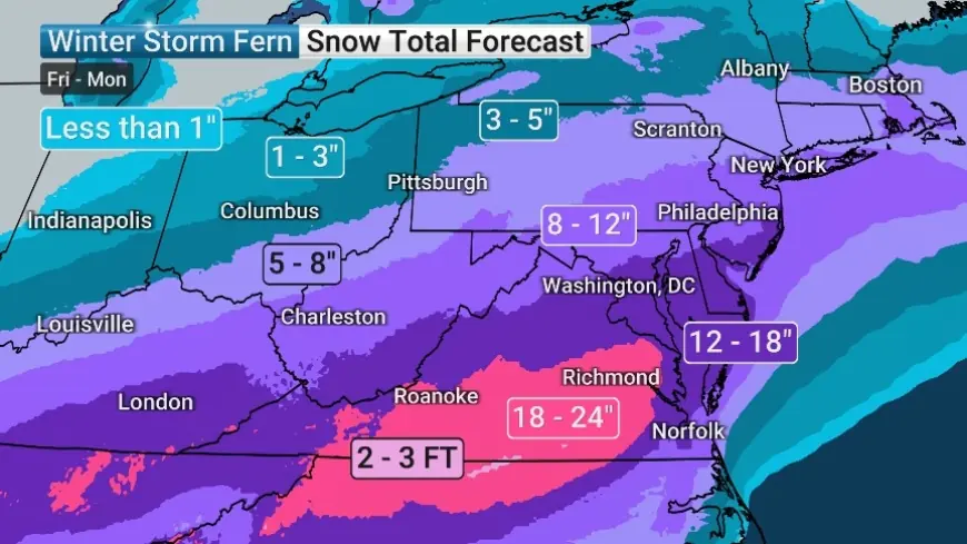
The Weather Channel is highlighting a Friday-to-weekend window for the first wave of significant impacts, with the storm expanding east and north as colder air digs in. The most disruptive period is expected from late Friday through Sunday (Jan. 23–25), with some areas still dealing with lingering snow/ice or cleanup into Monday (Jan. 26).
Here’s how the storm risk generally breaks down by region:
-
Southern Plains into the Mid-South (Friday into Saturday): wintry mix develops as cold air undercuts moisture, creating prime conditions for freezing rain and sleet.
-
Deep South into parts of the Southeast (Saturday into Sunday): icing risk expands east, and in some locations precipitation may change type as temperatures fluctuate near freezing.
-
Appalachians, Mid-Atlantic and Northeast (Sunday into early Monday): a colder, snowier side of the storm becomes the main story, with the potential for a plowable snow event in favored zones.
-
A widespread storm footprint is increasingly likely from Friday into the weekend.
-
The highest-impact hazard may be ice, not snow, across parts of the South.
-
The snow axis is expected to set up farther north, with the Mid-Atlantic and Northeast in play later in the weekend.
-
Dangerous cold behind the storm raises the risk of refreezing and prolonged slick conditions.
-
The storm track is still “wobbly,” meaning sharp cutoffs are possible over short distances.
Ice threat vs snow threat: why this weekend’s storm could be especially disruptive
Winter storms that combine ice and snow often cause the most widespread problems because impacts stack quickly: slick roads, downed branches, scattered power outages, and delayed emergency response times. The Weather Channel’s guidance emphasizes that the South’s risk is elevated because freezing rain can coat untreated roads and bridges rapidly, and many communities have fewer resources for de-icing compared with snow-prone regions.
Farther north, the main issue becomes snow rates and wind-driven visibility reductions, especially if heavier bands set up. Even where totals aren’t extreme, a burst of snow at the wrong time can snarl interstates, airports, and weekend travel.
A major complication this weekend is temperature “knife-edge” geography: one county can see cold rain while the next county sees glaze ice or heavy wet snow. That’s why last-minute shifts in the storm’s path matter so much.
What to do now: practical prep steps before the weekend storm arrives
If your area is inside the developing storm zone, a few realistic steps can reduce risk immediately:
-
Plan travel around the worst window: if you can move a trip earlier Friday or delay until after the weekend, do it.
-
Prepare for power interruptions: charge devices, stock batteries, and consider backup heat plans if you rely on electricity.
-
Protect pipes: insulate exposed pipes and let faucets drip in extreme cold where recommended locally.
-
Treat “roads look fine” as a trap: refreeze can create black ice after dark, even if the afternoon is manageable.
-
Check on vulnerable neighbors: ice storms especially can strand people quickly.
A short historical context: some of the most disruptive U.S. winter storms have not been the biggest blizzards, but the “messy” systems where ice forms first, then snow piles on, then temperatures plunge—locking in hazardous conditions for days. This weekend’s setup carries a similar risk profile in places that end up on the icy side of the storm.
What to watch as the forecast updates: the three signals that decide who gets what
Over the next 24–48 hours, these are the forecast details that will determine whether your location sees rain, ice, or snow:
-
Storm track: a small shift north or south can move the heavy snow band and redraw the ice corridor.
-
Warm layer aloft: if warm air rides over shallow cold air near the ground, freezing rain becomes more likely.
-
Timing of cold air arrival: earlier cold air favors sleet/snow; later arrival favors rain changing to ice late.
If The Weather Channel updates maps showing a tightening, more consistent snow/ice corridor, that usually indicates forecasters are gaining confidence. If the corridor keeps shifting from update to update, plan for a wider range of outcomes.
FAQ
Is The Weather Channel calling for a winter storm this weekend?
Yes. The current outlook points to a large, high-impact winter storm from Friday into the weekend with ice and snow threats across a broad swath of the South and East.
What’s the biggest danger: snow or ice?
For many southern areas, ice is the bigger hazard because it can cause power outages and makes roads dangerously slick. Farther north, snow and reduced visibility may be the main issue.
Could the forecast change before the weekend?
Yes. Storm track and temperature profiles can still shift, especially near the rain/ice and ice/snow boundaries, so updates over the next day or two are critical.
As the weekend approaches, expect sharper call-outs on which metro areas face the highest odds of heavy ice versus heavy snow. The safest play is to treat Friday night through Sunday as the most disruption-prone window, build in extra time for any travel, and prepare for conditions to worsen quickly once temperatures fall below freezing.


