


Snow Storm Weather Forecast: Lake-Effect Whiteouts Now, Then a High-Impact U.S. Snow-and-Ice Threat January 23–25
A volatile winter pattern is setting up two distinct snow-storm hazards: (1) short-fuse, intense lake-effect snow that can flip visibility from clear to near-zero in minutes across parts of the Great Lakes, and (2) a broader late-week storm system with the potential to spread disruptive snow, sleet, and freezing rain across a long corridor of the central and eastern United States from Friday through Sunday, January 23–25. Where the heaviest impacts land will depend on the storm track and a narrow temperature “knife edge” near the freezing mark.
Snow storm weather forecast: What’s happening right now (Great Lakes and interior Northeast)
The immediate snow risk remains highest downwind of the Great Lakes, where wind direction and lake temperatures can focus narrow bands of heavy snow. These bands often produce:
-
Sudden whiteouts (visibility dropping to near zero)
-
Rapid accumulation in localized swaths (a few miles apart can mean very different totals)
-
Blowing and drifting snow, especially in open areas
The cold air mass behind this pattern also raises the stakes. Even when snowfall rates briefly ease, roads can stay slick due to refreezing, and wind chills can turn minor delays into serious safety issues.
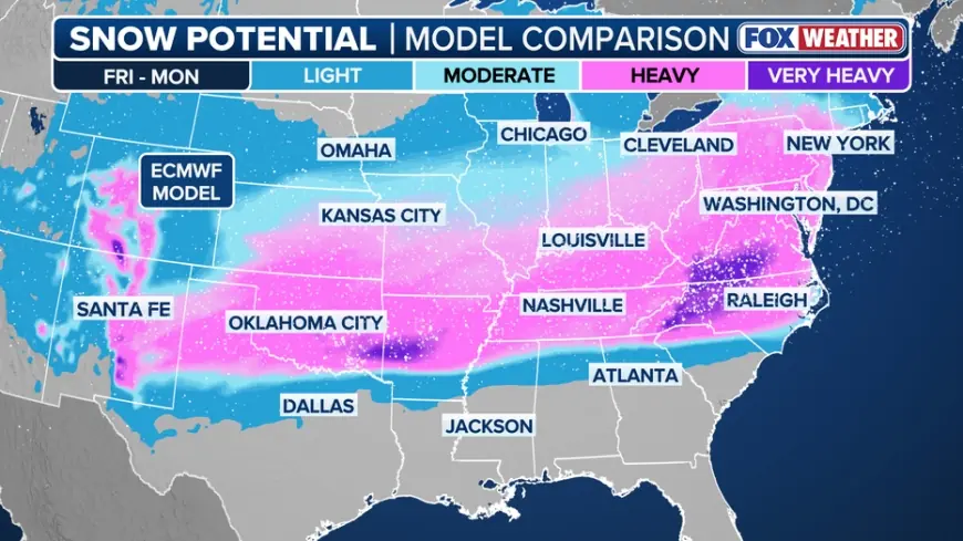
The big weekend system: Snow, ice, and travel disruption January 23–25
The larger late-week storm is the one most likely to cause widespread disruptions. The leading edge is expected to develop across the southern Plains, then expand toward the Mississippi and Tennessee Valleys and into parts of the Mid-Atlantic and Northeast.
The biggest problem isn’t just “how much snow,” but “what type.” Many areas may sit in a transition zone where precipitation changes from rain to freezing rain to sleet to snow over short distances—and those transitions can shift as the storm evolves.
Most likely impact zones
-
Heavy snow zone (north/west side of the storm): fastest accumulation, difficult travel, potential for blowing snow if winds increase
-
Sleet/freezing rain zone (near the rain–snow line): highest risk for crashes, tree damage, and power outages
-
Cold rain zone (south/east side): flooding is possible where heavier rain falls on frozen ground or clogged drains
Timing guide for the late-week storm (ET and GMT)
| Region | Most likely impact window | Primary risk |
|---|---|---|
| Southern Plains | Fri Jan 23 (late)–Sat Jan 24 | Ice/sleet and pockets of snow |
| Lower Mississippi & Tennessee Valleys | Sat Jan 24 | Mixed precip, icing risk |
| Carolinas / Mid-Atlantic | Sat Jan 24–Sun Jan 25 | Ice then snow (track dependent) |
| Northeast interior | Sun Jan 25 | Snow potential; mix closer to coast |
Schedule is subject to change as the track tightens.
Why forecasts may swing: the “32°F problem”
A 1–2°C change at the surface can flip outcomes from manageable snow to damaging ice. Ice tends to form when:
-
Surface air stays at or below freezing
-
Warmer air slides in above the surface (creating rain that freezes on contact)
That’s why the most important line on the map is often not the bullseye for snowfall, but the corridor where temperatures hover near 32°F (0°C). If your area is close to that threshold, expect forecast changes up until the event begins.
What to do now: practical preparation for a snow/ice weekend
If you’re in any potential impact area for January 23–25:
-
Charge phones and power banks; check flashlights and batteries
-
Stock essentials for 48 hours (water, shelf-stable food, needed medications)
-
Top off your vehicle’s fuel and keep a winter kit (blanket, gloves, snacks, ice scraper)
-
Avoid “must-travel” plans during the peak window; ice is far more dangerous than snow
-
If you rely on electric heat or medical devices, plan for backup power options
If you meant a local snow storm weather forecast
“Snow storm weather forecast” depends heavily on your city. If you tell me your location (city + country/state), I’ll give a tight, local forecast with:
-
Start/end times
-
Expected precipitation type (snow vs sleet vs freezing rain)
-
Best estimate of accumulation range
-
The most likely “worst travel” window in your area


