


Snowfall and Winter Storm Warnings Across New York: Lake-Effect Pounds Buffalo Area While NYC Stays Dry Today
A sharp winter pattern is gripping New York on Tuesday, January 20, with two very different stories unfolding at once: intense, banded lake-effect snow driving hazardous travel and school closings in Western New York, and a bitter-cold but mostly dry day in New York City. Forecasters are also watching a separate storm potential for late week into the weekend, but the immediate concern is what’s already on the ground—plus what’s still falling in the most persistent lake bands.
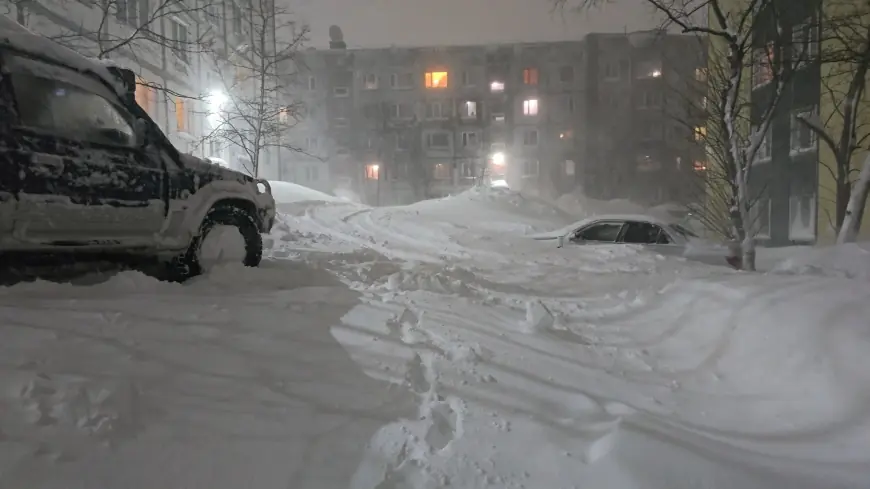
Buffalo Weather: Lake-Effect Snow Keeps Western New York on Edge
The Buffalo region remains under a winter storm warning focused on Northern Erie and Genesee counties through Wednesday afternoon. The warning highlights additional accumulation on the order of a few inches for the metro area, but travel impacts can spike quickly because lake-effect bands don’t spread snow evenly—one neighborhood can see steady bursts while another is merely flurrying.
Winds are also a factor. Gusts strong enough to whip blowing and drifting snow can rapidly cut visibility, especially on open stretches of roadway and along the Thruway corridor. Even when totals sound modest, short-lived near-whiteout conditions are what turn commutes into multi-hour crawls.
How Many Inches of Snow Today: Buffalo Area vs. NYC
Because “today’s snow” depends heavily on location, here’s the clearest way to frame it for Tuesday, January 20:
-
Buffalo metro (general): Many communities have logged several inches in the last 24 hours, with typical reports clustering around the mid-single digits to low teens depending on where the band set up.
-
Southtowns and snowbelt pockets: The highest totals are showing up south and southeast of the city, where some locations have seen well over 1 foot in the past day, with a few reports in the 20+ inch range.
-
NYC (today): 0 inches expected today in the city—Tuesday is dominated by sun and cold air, not snowfall.
If you want the most accurate “today” number for Buffalo, the key is your exact neighborhood (North Buffalo vs. South Buffalo vs. suburbs) because a shift of a few miles can change totals dramatically.
School Closings in WNY: Why Tuesday’s List Grew Quickly
With lake-effect snow creating highly localized but high-impact road conditions, multiple districts across Erie and Niagara counties opted to close for Tuesday, January 20. Among the confirmed closures are:
-
Buffalo Public Schools
-
Niagara Falls City School District
-
Lockport City School District
In lake-effect events, closings often cascade: one district closes, neighboring districts reassess bus routes on untreated side streets, and the list expands as visibility and plow progress change. If you’re in the Buffalo area, it’s worth re-checking district alerts even midday for after-school activities, athletics, and evening events—those are frequently canceled separately.
Syracuse Weather: The Bigger Warning Is East of the City
Syracuse itself is mainly dealing with cold, wind, and periodic snow showers, but the highest-impact warning zone in Central New York is closer to the eastern Lake Ontario snowbelt. That region is facing a longer-duration winter storm warning that runs into Friday evening, driven by repeated rounds of lake-effect snow and wind.
The key issue there isn’t just accumulation—it’s the combination of:
-
very high snowfall rates at times,
-
blowing snow reducing visibility,
-
and long-duration banding that can bury secondary roads faster than crews can keep up.
NYC Weather: Cold, Bright, and Quiet—for Now
New York City’s weather story is simple today: sunshine and bitter cold. Roads are generally fine, but the cold can be dangerous for anyone outside for extended periods, especially early and late. Wind can make it feel even colder than the thermometer suggests.
As for snowfall: if you’re asking “how many inches of snow today in NYC,” the answer is none for Tuesday. Any snow you see is leftover from earlier systems, not new accumulation.
Winter Storm Warnings and What’s Next
The immediate focus remains lake-effect warnings upstate and in the snowbelt regions. Looking ahead, forecasters are also monitoring storm potential later in the week into the weekend that could bring a broader, more classic snowfall footprint toward the I-95 corridor. That part is still subject to track and timing changes, but it’s on the radar.
Safety Snapshot: The Two Biggest Risks Right Now
-
Whiteouts and sudden slick spots in WNY: Slow down well before braking zones, avoid passing snowplows, and keep extra distance.
-
Dangerous cold statewide: Dress in layers, cover exposed skin, and limit time outside—especially for kids at bus stops and anyone working outdoors.
If you tell me your neighborhood (Buffalo suburb or NYC borough) and what time window you mean by “today” (morning vs. all day), I can narrow the snowfall and travel-impact guidance to your exact area.


